


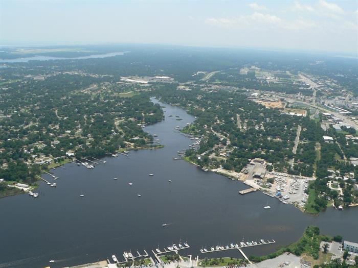
Bayou Chico is located within the Pensacola Bay watershed in south central Escambia County. The bayou has a surface water area of approximately 235 acres with a surrounding drainage basin of more than 6,600 acres. The eastern half of the bayou and associated contributing basin is generally located within the City of Pensacola with the remaining western bayou and associated contributing basin located outside city limits in unincorporated Escambia County.
Three main freshwater tributaries flow into Bayou Chico from the surrounding watershed. Jones Creek, the largest of the three tributaries, flows east through Jones Swamp and Warrington eventually forming the western arm of the bayou. Jackson Creek flows east through west Pensacola eventually forming the west end of the north arm of the bayou. A third tributary known as Maggie’s Ditch flows west through portions of the City of Pensacola eventually forming the east end of the north arm of the bayou.
Bayou Chico is widely considered one of the most historically contaminated water bodies in Florida. Total Maximum Daily Loads have been approved by the Florida Department of Environmental Protection for fecal coliform bacteria and excess nutrients. A Basin Management Action Plan, or BMAP, was adopted by FDEP in 2011 to address the fecal coliform TMDL. Numerous scientific studies have documented elevated levels of heavy metals (cadmium, chromium, copper, lead, mercury), polycyclic aromatic hydrocarbons (PAHs) (benzo(a)-pyrene, anthracene, acenaphthene), pesticides (chlordane, DDD, DDT, endrin, dieldrin, Mirex), and polychlorinated biphenyls (PCBs) in the bayou sediments.
Federal, state and local stakeholders have since spent millions of dollars on water quality improvement, stormwater retrofit, and sewer expansion projects within the watershed. Despite recent gains, additional effort is still needed. Significant administrative and civil penalties related to the Deepwater Horizon Oil Spill have resulted in millions in addition funding opportunities for Bayou Chico.
The project will improve benthic habitat and surface water quality within Bayou Chico through the remediation of contaminants found within the bayou sediments. The project also seeks to enhance economic and recreational opportunities along the working waterfront. The Gulf Coast Ecosystem Restoration Council awarded $335,000 to Escambia County through FDEP for planning, engineering, design, and permitting. An additional $12± million is expected for implementation of the eventual remediation plan from the Board of County Commissioners submittal through the Gulf Consortium to the State of Florida Implementation Plan.
Monthly RESTORE Project UpdatesThe overall project consists of five individual project located throughout the Bayou Chico watershed. This suite of projects will reduce sediment and nutrient loading to Bayou Chico, reduce turbidity, increase water clarity, and improve light penetration for photosynthesis to enable expansion of submerged aquatic vegetation habitat. The projects will continue implementation of the overall restoration of Bayou Chico and will complement or accelerate planned restoration activities identified in the Florida Department of Environmental Protection’s Basin Management Action Plan, or BMAP, for the bayou. The projects include both stormwater treatment and stream restoration elements. The National Fish & Wildlife Foundation awarded a total of $11,032,300 through the Gulf Environmental Benefit Fund to implement all five projects.
The project will expand the installation of new stormwater and sewer infrastructure into an additional 175 acres of existing residential neighborhoods within Beach Haven. Project boundary extends west from Decatur Avenue to Fairfield Drive. Project partners include Escambia County and Emerald Coast Utilities Authority. The Gulf Coast Ecosystem Restoration Council awarded $5,967,000 to Escambia County through FDEP for design, permitting, and construction.
Monthly RESTORE Project UpdatesBayou Chico has a FDEP approved Total Maximum Daily Load for fecal coliform bacteria. A BMAP was adopted by the State in 2011 to address elevated bacteria levels routinely observed in the bayou and associated tributaries. Since its inception, more than a dozen key federal, state, and local stakeholder groups have been collaborating and cooperating on a developing a surface water monitoring program and implementing targeted projects. Project partners include FDEP, Escambia County, City of Pensacola, Emerald Coast Utilities Authority, Florida Department of Transportation, Florida Department of Health, U.S. Navy, University of West Florida, and the Bayou Chico Association.
Bayou Chico Fecal Coliform BMAPThe Natural Resources Management Department has completed a study of the fine-grain sediment located throughout Bayou Chico. The study represents one of the first tangible steps toward developing a remediation plan for the bayou. County scientists were able to accomplish all four of the following project goals. 1) Delineate distribution of fine-grain sediment 2) Develop an estimate of overall volume of fine-grain sediment 3) Collect data necessary to guide future planning activities 4) Conserve funding available for project planning by completing study utilizing existing county resources.
The Florida Department of Environmental Protection hosted its annual Bayou Chico Basin Management Action Plan, or BMAP, meeting on Jan. 18, 2018. The BMAP was adopted by the State of Florida in 2011 to address a fecal coliform based Total Maximum Daily Load. The purpose of the meeting was for stakeholders to discuss recent efforts to implement projects and strategies identified in the adopted BMAP. The 2017 annual progress report will be posted to FDEP’s website at the link provided below as soon as it becomes available.
FDEP BMAP Annual Progress ReportsThe mission of Escambia County government is to provide efficient, responsive services that enhance our quality of life, meet common needs and promote a safe and healthy community.
Under Florida law, IP addresses and both the content of emails and email addresses are public records. If you do not want your IP address, the content of your email, or your email address released in response to a public records request, do not send electronic mail to this entity. Instead, contact this office by phone or in person.
All content © 2026 Escambia County, FL and its representatives. All rights reserved.