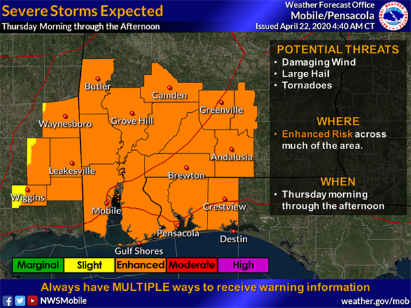
Escambia County is encouraging residents to closely monitor the weather forecast this week and take precautions as needed through Thursday, April 23. The National Weather Service of Mobile is forecasting local impacts to include rainfall, potentially damaging straight line winds, possible tornadoes, large hail, high risk of rip currents and high surf.
According to NWS of Mobile, numerous rounds of storms are expected to develop during the day Thursday morning and persist into Thursday afternoon. Frequent wind gusts of 25-35 mph are likely on Thursday, outside of thunderstorm activity. Rainfall of 1 to 2 inches is expected through Thursday afternoon.
Follow these tips to stay safe during severe weather:
- Pay extra attention to local weather reports until the storm has moved through the area. Be sure to keep your weather radio on and your cell phone charged to ensure you can receive weather alerts.
- With the possibility of high winds, it is recommended that any lightweight outside furniture or equipment be secured before Thursday morning.
- Organizations with planned outside activities during this Enhanced Risk period need to be weather aware and take the appropriate actions.
Tornado safety tips from the National Weather Service:
- GET IN - If you are outside, get inside. If you're already inside, get as far into the middle of the building as possible.
- GET DOWN - Get underground if possible. If you cannot, go to the lowest floor possible.
- COVER UP - Flying and falling debris are a storm's number one killer. Use pillows, blankets, coats, helmets, etc to cover up and protect your head and body from flying debris.
- An extensive list of tornado safety tips and scenarios is available at weather.gov/ama/severesafetytips.
For the latest information on severe weather impacting Escambia County, residents are encouraged to sign up for emergency alerts on myescambia.com, like Escambia County Emergency Management on Facebook and follow @BeReadyEscambia on Twitter.
Tips to maintain COVID-19 best practices while sheltering during severe weather:
Stay informed with these additional local resources:

