Overview
|
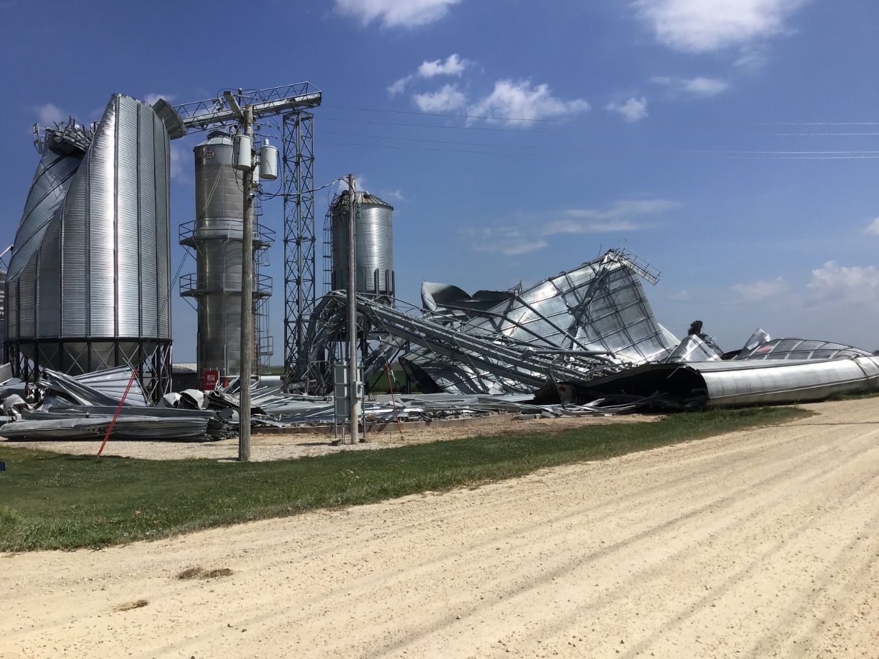
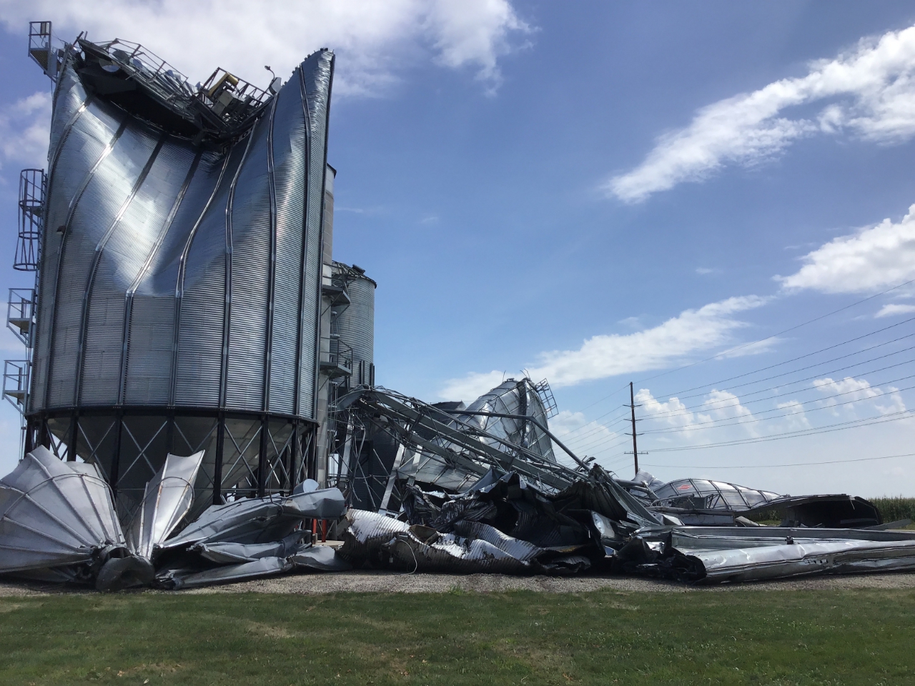
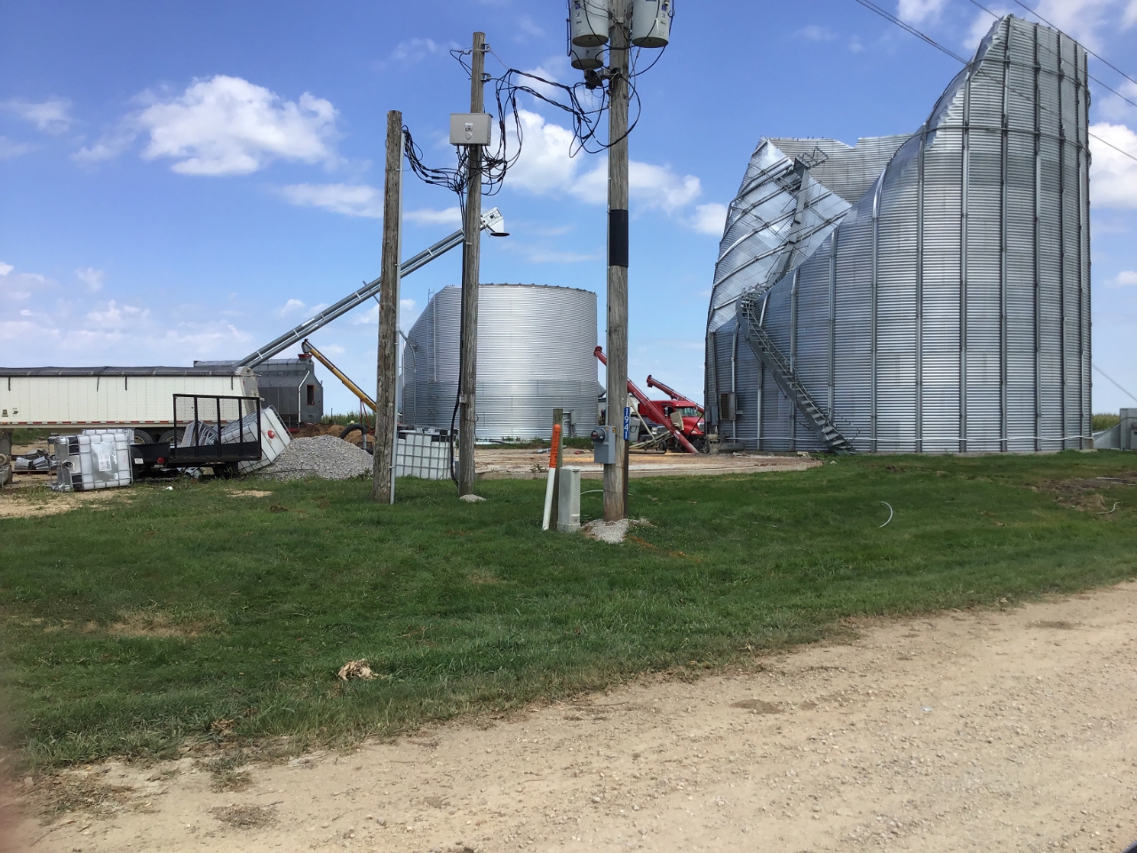
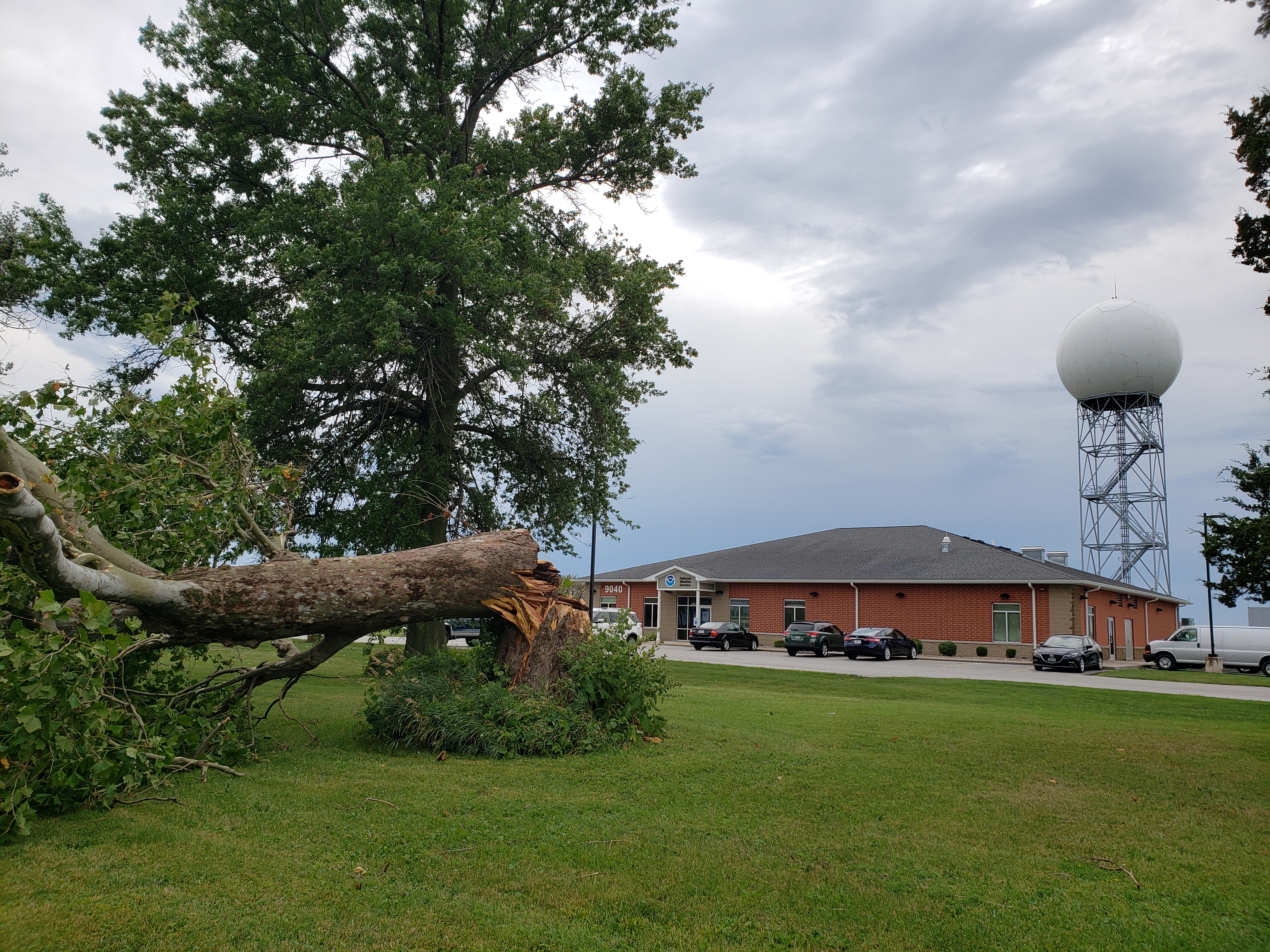
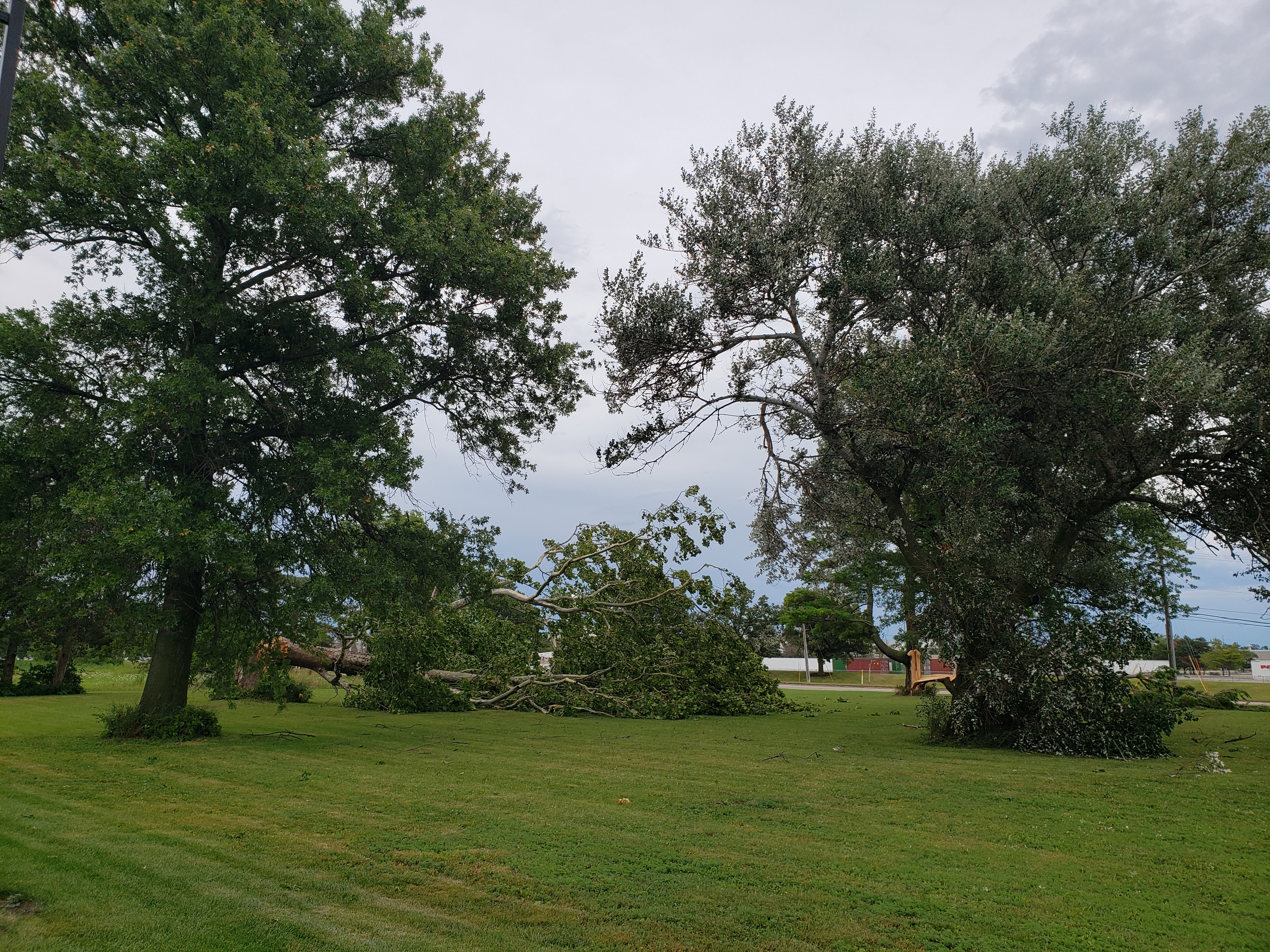
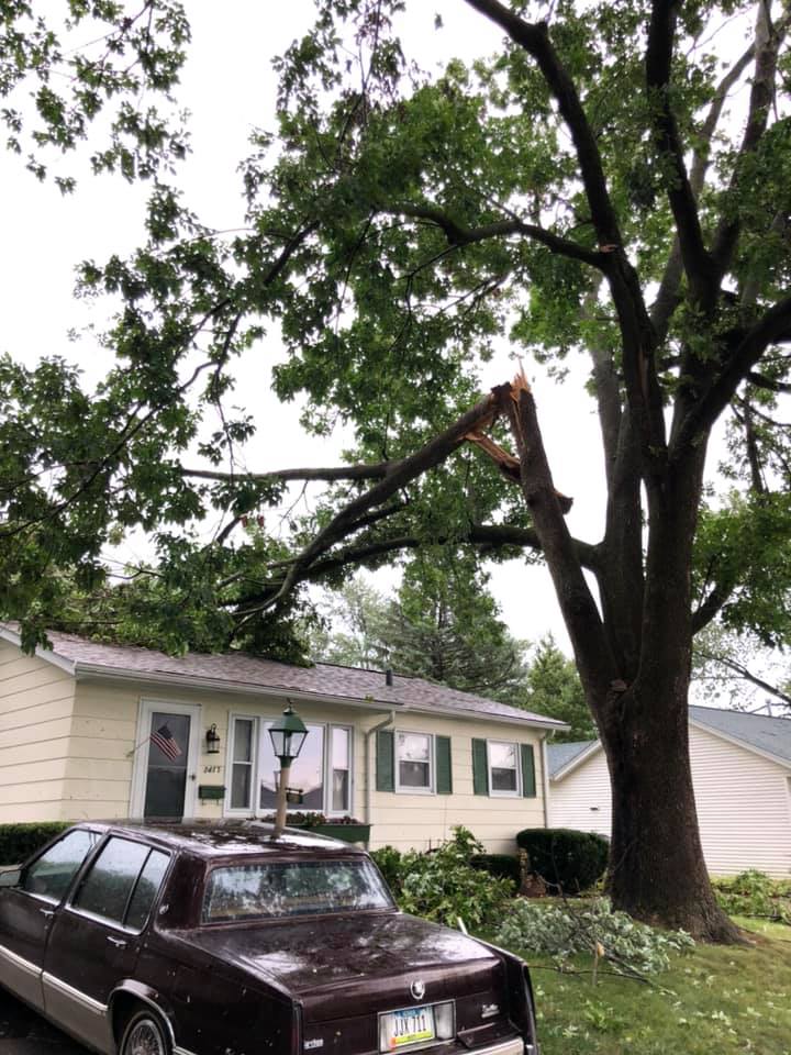
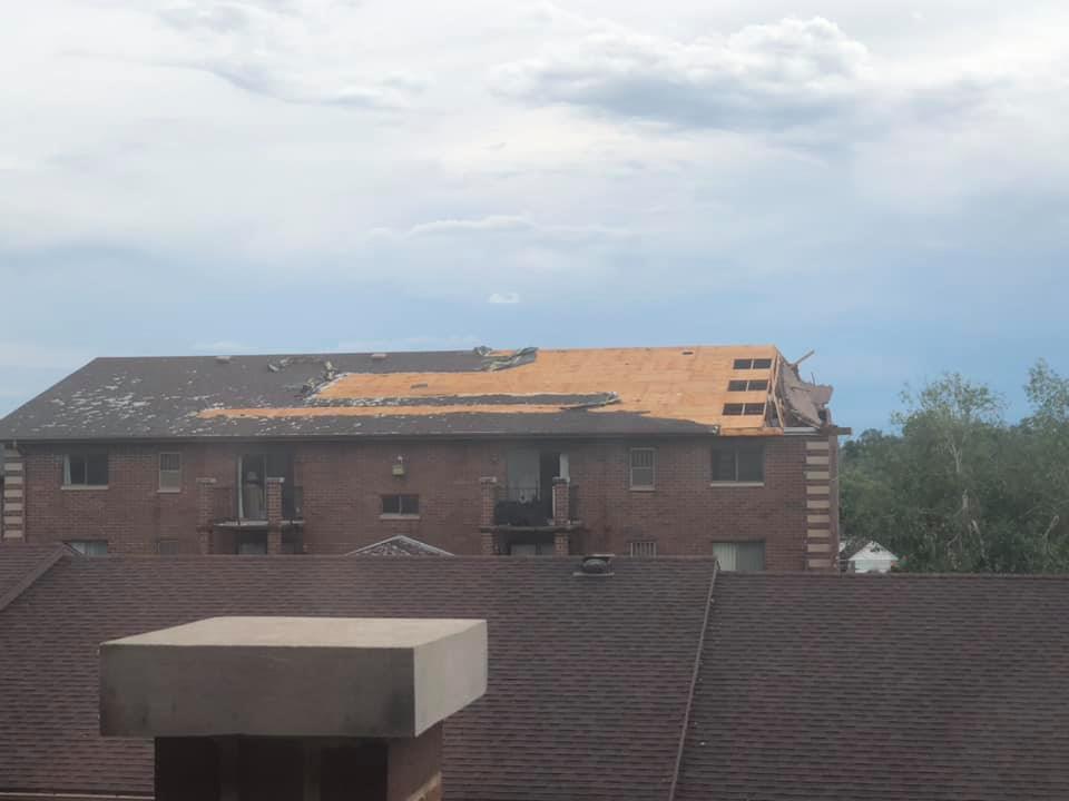
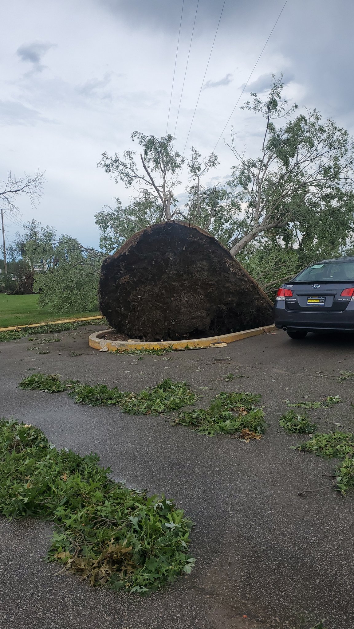
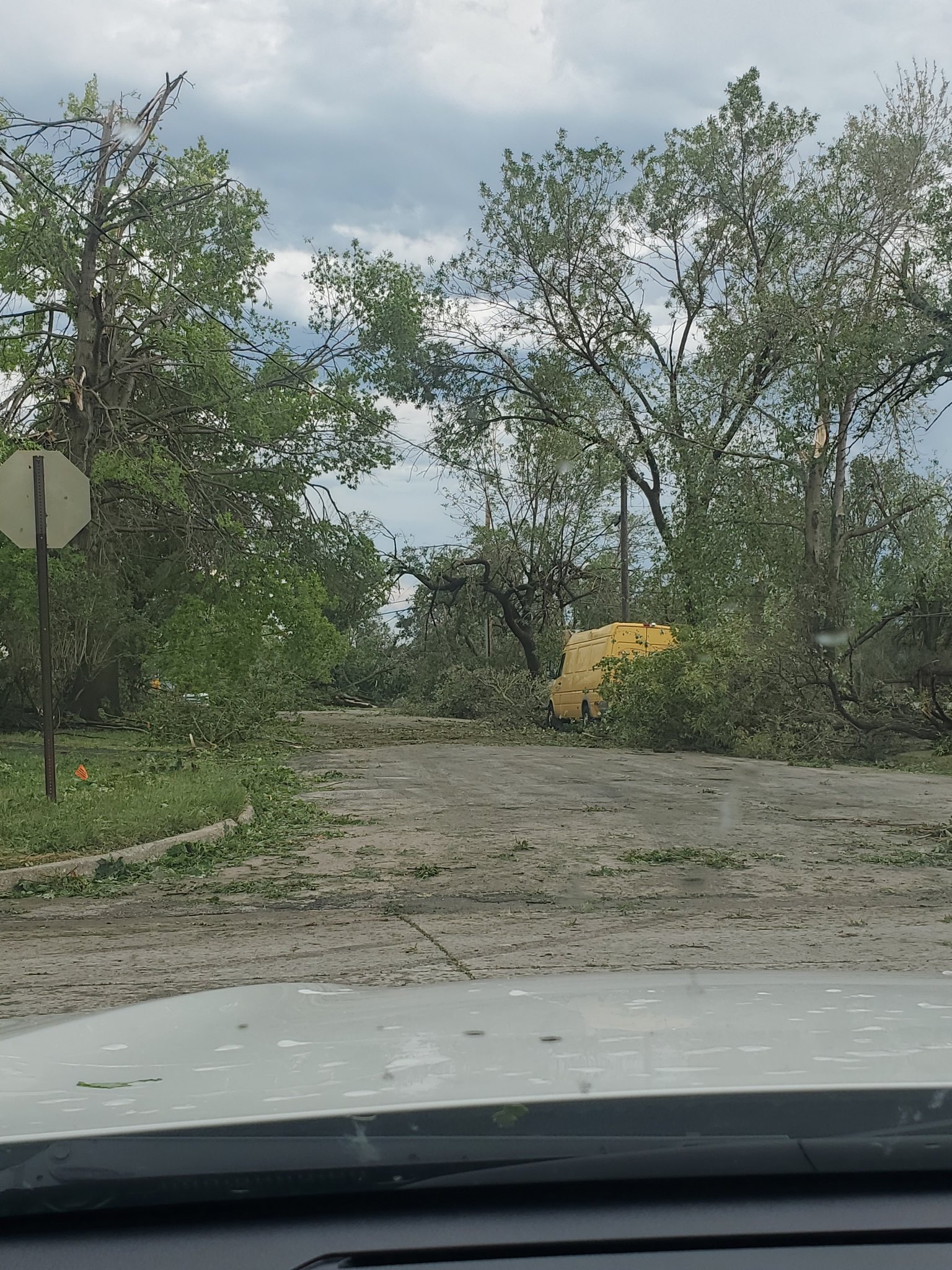
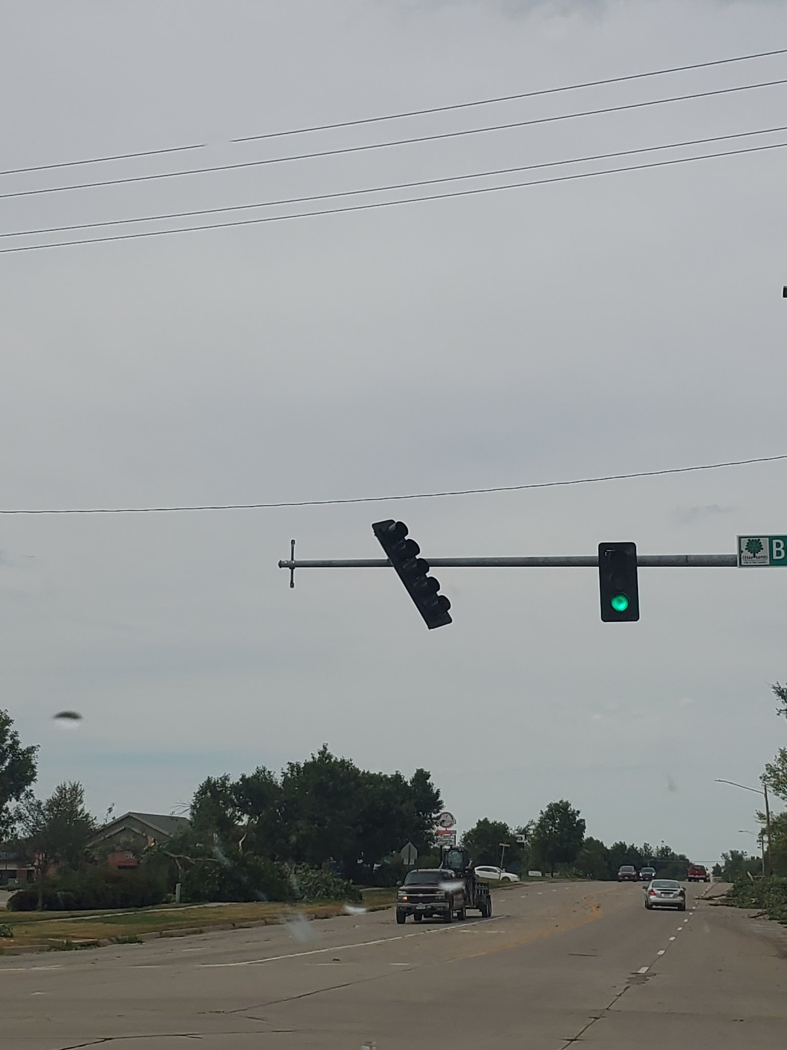
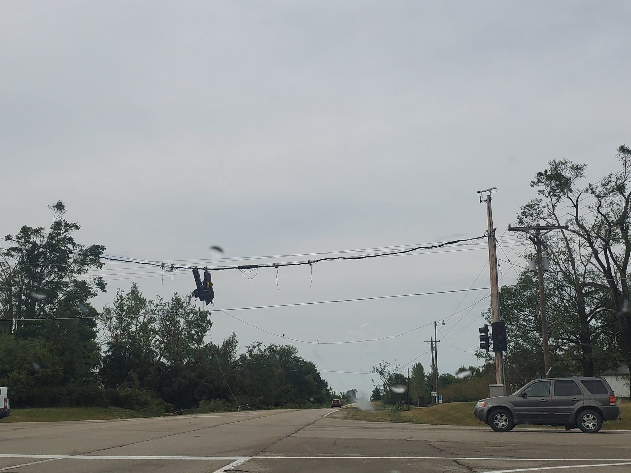
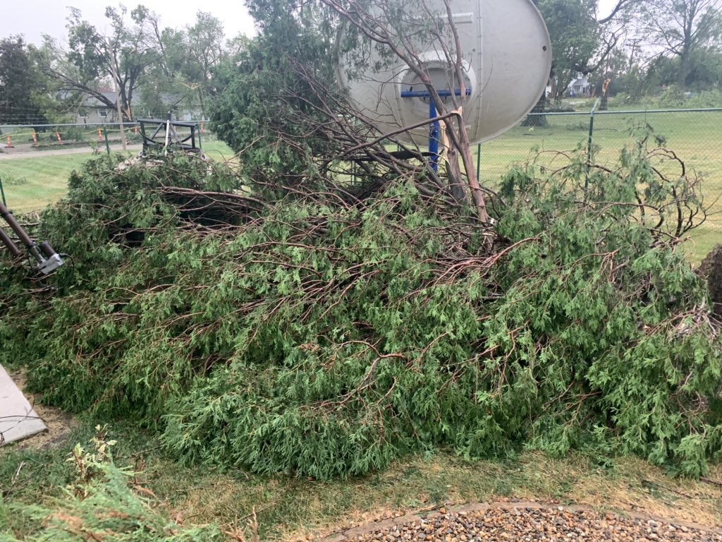
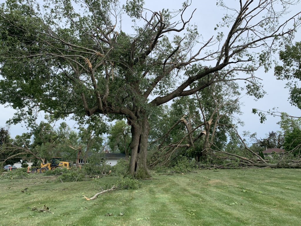
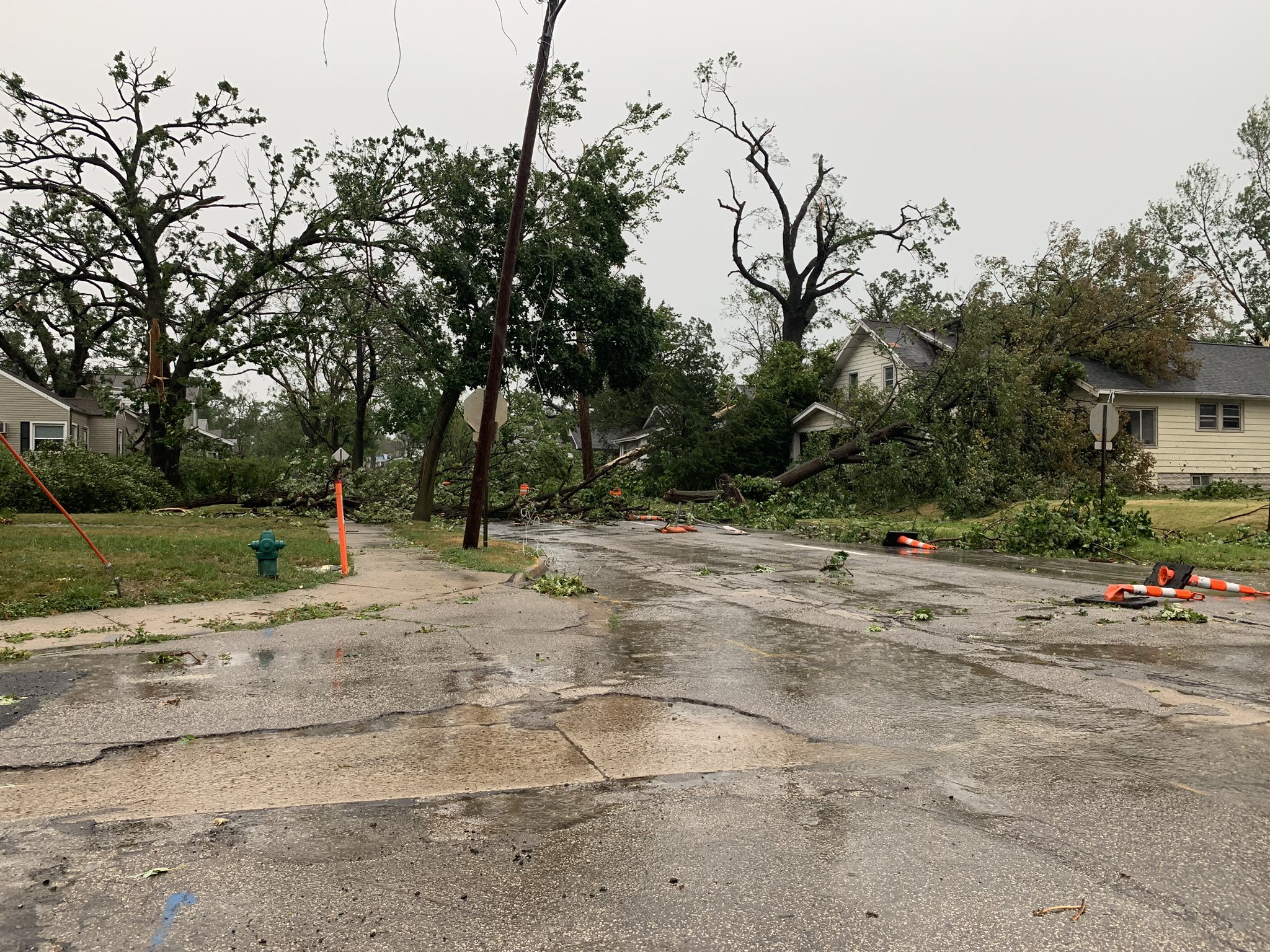
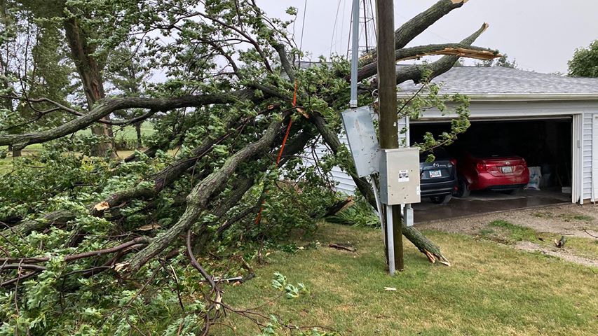
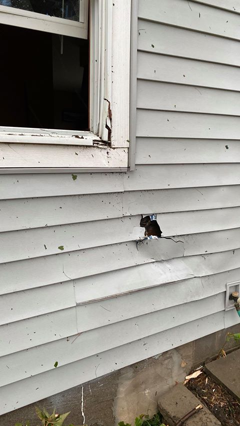
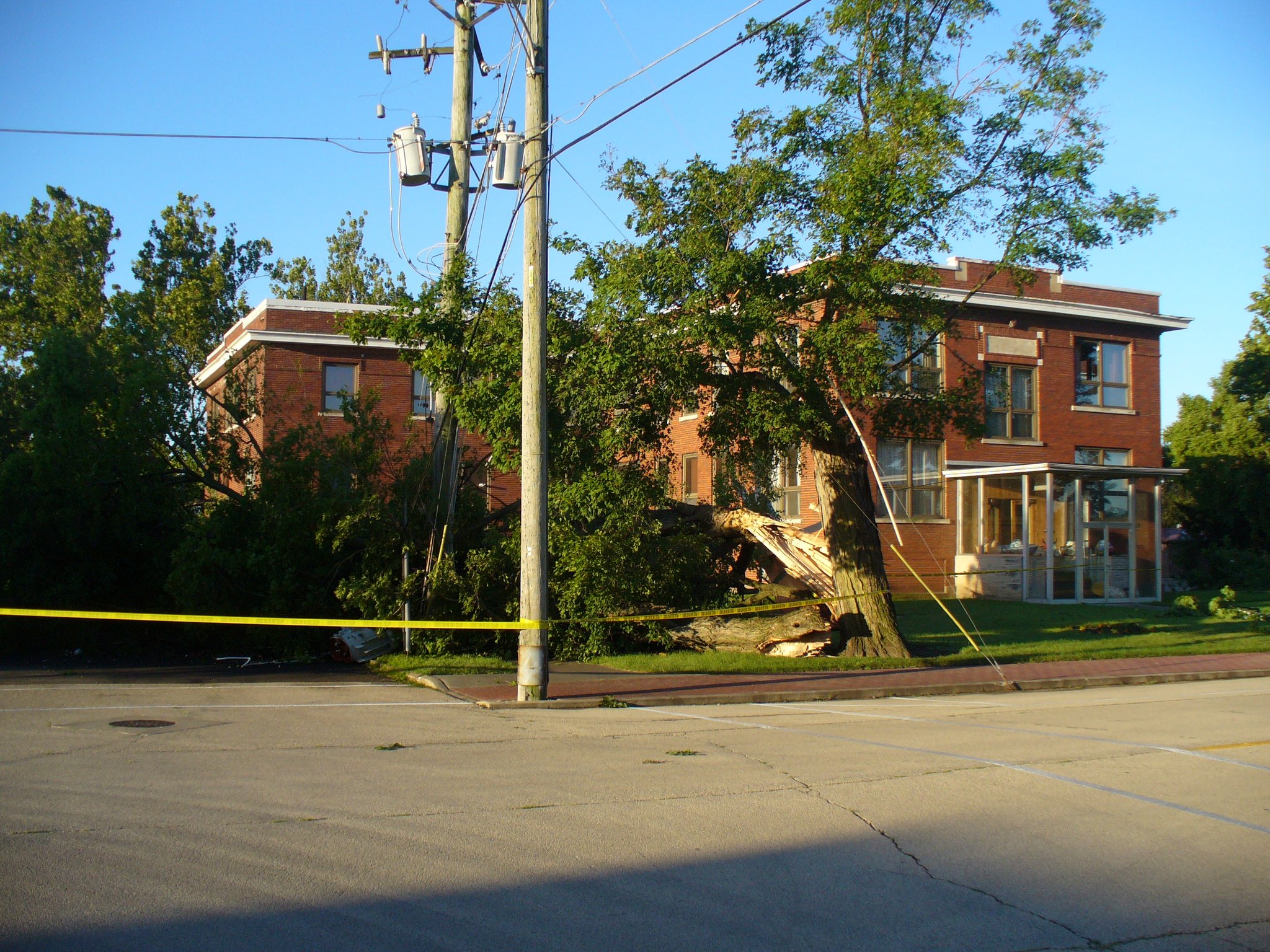
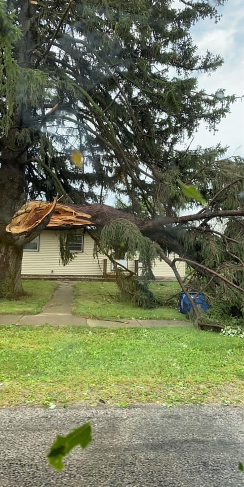
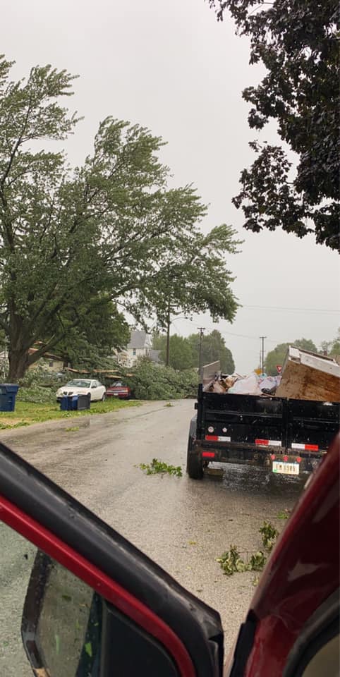
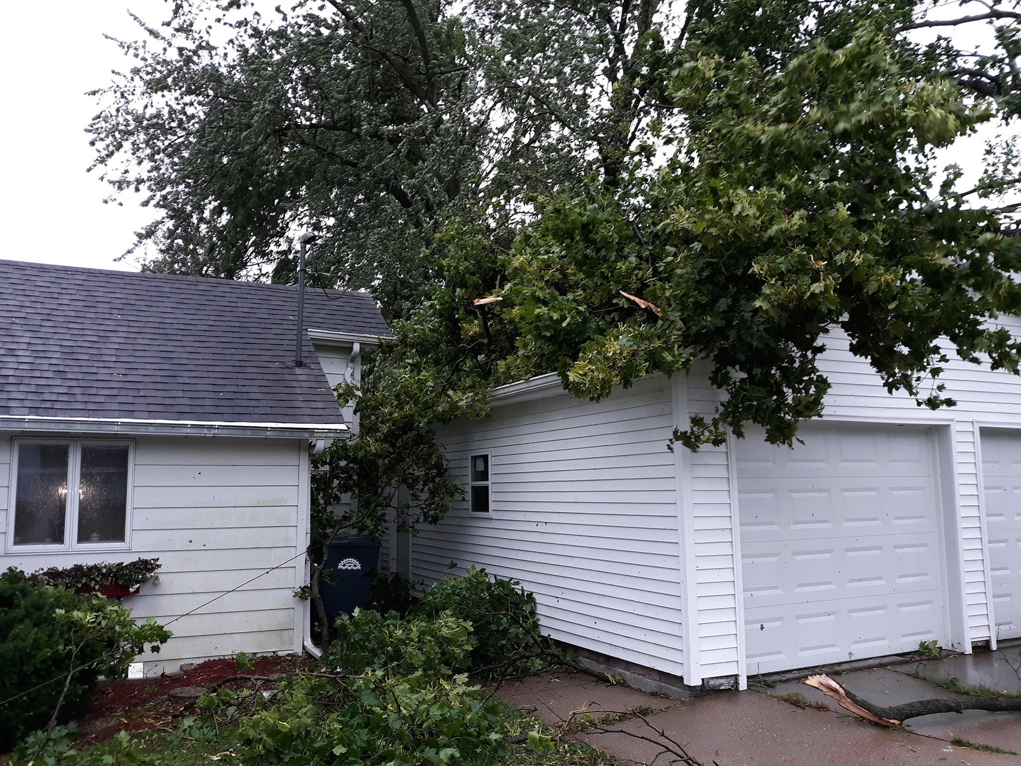
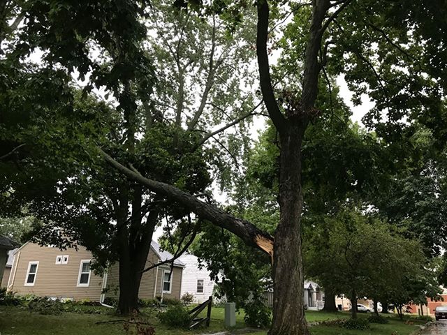
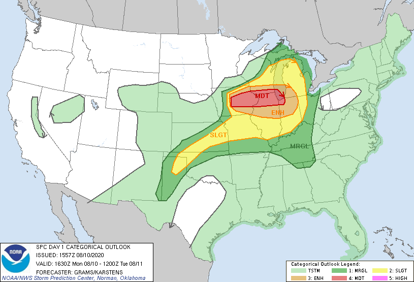
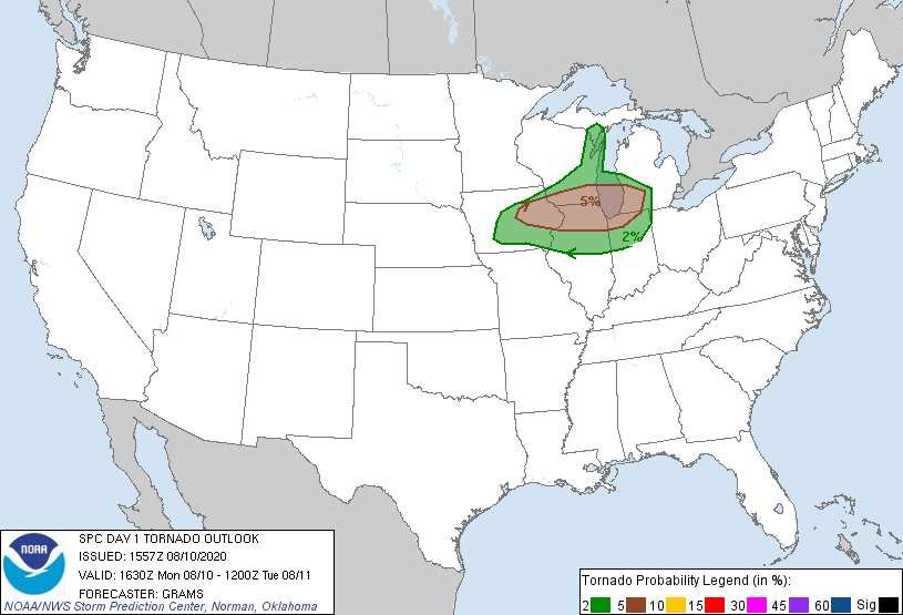
A powerful line of severe thunderstorms known as a "Derecho" tracked across eastern Iowa and northwest Illinois on the afternoon of Monday, August 10th resulting in widespread straight line wind damage. A swath of damage from Benton County, through portions of Linn, Jones, Cedar, and Clinton Counties, is consistent with intermittent straight line winds in the 100-130 mph range. Maximum estimated winds were around 140 mph, which caused extensive damage to an apartment complex in southwest Cedar Rapids, IA. The maximum measured unofficial wind gust was 126 mph at Atkins, Iowa in Benton County. Two tornadoes were also confirmed within the widespread swath of wind damage, Both have been designated as EF-U (unknown), as there was no observable damage directly attributable to the tornadoes from which an EF-scale rating could be assigned. A derecho of this intensity is a roughly once-in-a-decade occurrence in this region. Other notable derechos occurred in 1998 and 2011. What is unique about this event, making it even more extreme, is the long duration of the high winds. Many locations experienced sustained high winds and damaging gusts for 30 to 60 minutes, compared to 10 to 20 minutes, which is more common for derechos. One storm-related fatality occurred in the NWS Quad Cities area of responsibility. The Linn County Sheriff's Department reports a bicyclist died after being struck by a falling tree. There were numerous injuries reported, especially in the Cedar Rapids area. Storms initially developed in northern Nebraska and southeast South Dakota early in the morning, and quickly intensified as they moved eastward into Iowa. Storms quickly became severe in western Iowa, and produced damaging winds near and around the Des Moines metro. At this point, storms began to tap into an extremely unstable environment, and began producing more widespread wind damage as they tracked through eastern Iowa. The most extreme winds, estimated at 110-140 mph, destroyed or damaged numerous outbuildings, barns, grain bins, homes, mobile homes, apartment buildings, trees, and power poles in parts of Benton, Linn, Jones, Cedar, and Clinton Counties. The Cedar Rapids area was particularly hard hit. Several homes, apartment complexes, and businesses sustained damage consistent with 130-140 mph winds. Radio transmission towers in Marion and Clinton, IA collapsed due to winds estimated around 130 mph. Winds gusts of 80-100 mph were common as the line of storms moved through the Quad Cities area and then through northwest Illinois. A small pocket of winds estimated at 100-110 mph impacted Princeton, IL in Bureau County, where a 150 foot communications tower collapsed and numerous power poles were snapped. In addition to the damage, numerous long-duration power outages occurred across the region, and millions of acres of crops were damaged or destroyed. Numerous semi trucks were also blown off of major highways. NOTE: This information is preliminary. The National Weather Service thanks Emergency Management and media partners, as well as the public, for assistance with remote surveys. |
 |
 |
 |
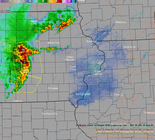
| Radar Animation From the Advanced Weather Interactive Processing System (AWIPS) display inside KDVN. Severe Thunderstorm Warnings are lined in yellow, with Tornado Warnings in red. |
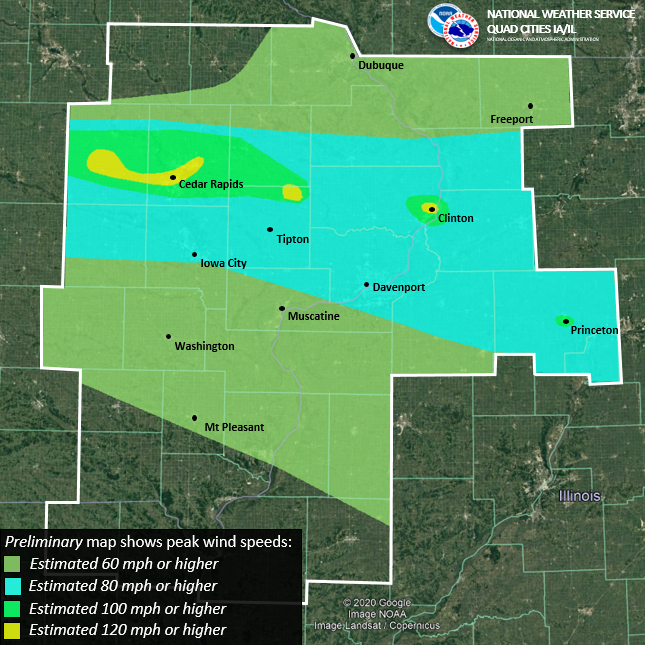
Graphic showing preliminary peak winds |
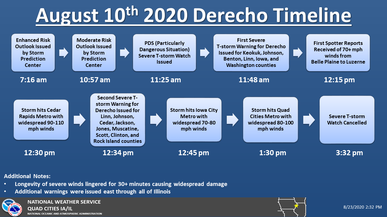
Timeline of Watch/Warnings/Reports During Event |
Video from northern Cedar Rapids near intersection of Blairs Ferry Rd and C Ave. Courtesy: Evan Hindman
Photos & Video
NWS Survey 8/17/20
 |
 |
 |
 |
|
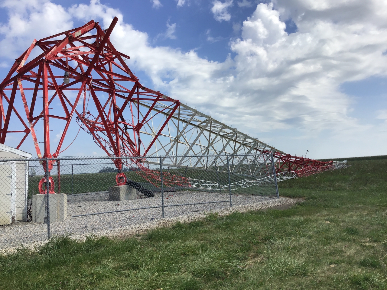
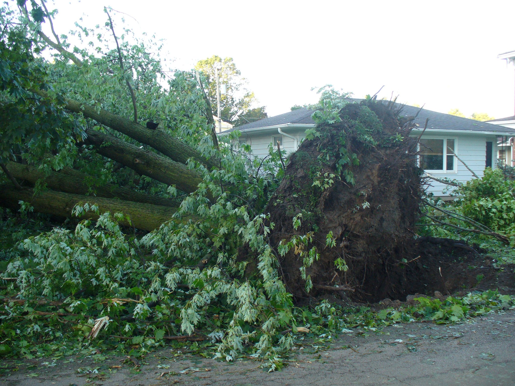
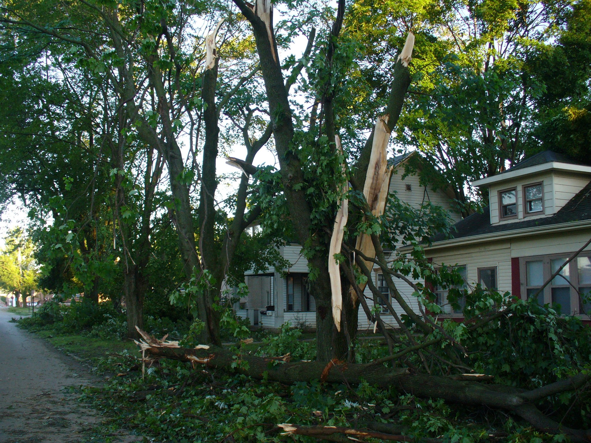
| WMT Tower north of Marion,IA (NWS Survey) |
Marion, IA (NWS Survey) |
Marion, IA (NWS Survey) |
northern Cedar county (NWS Survey) |
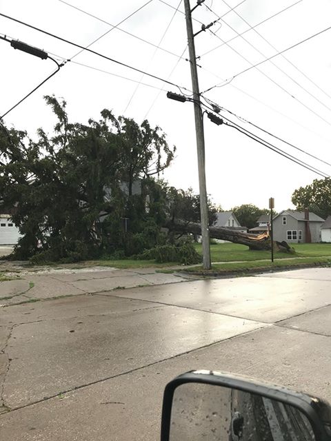
Quad Cities IA/IL
 |
 |
 |
 |
|
| (Peter Speck) | (Peter Speck) | (Jessica Brooks) | (Kristi Snowbarger) |
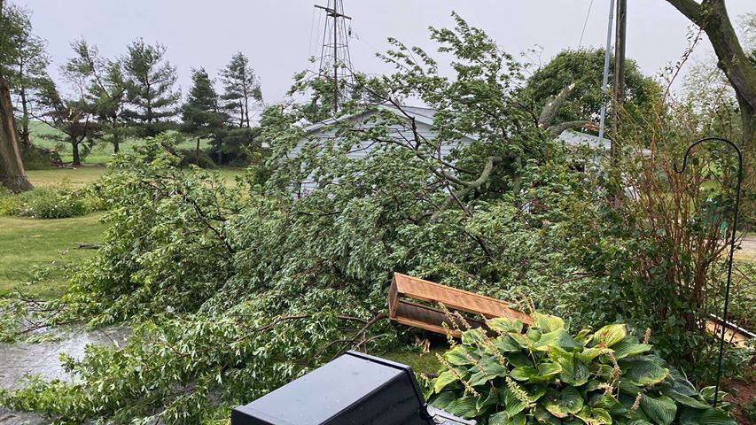
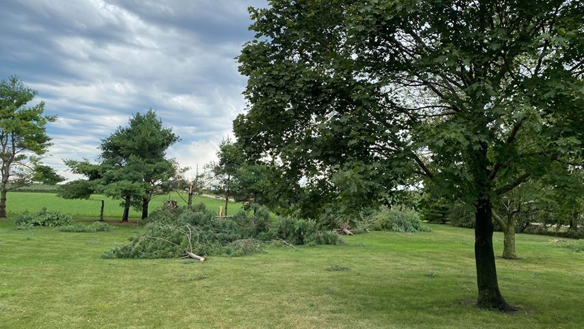
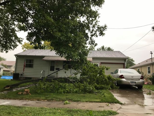
Cedar Rapids/Iowa City
 |
 |
 |
 |
 |
| (Kiah Snow) | (Rebecca Kopelman) | (Rebecca Kopelman) | (Rebecca Kopelman) | (Rebecca Kopelman) |
 |
 |
 |
| (Sara Flynn) | (David Amelotti) | (Gillian Brooks) |
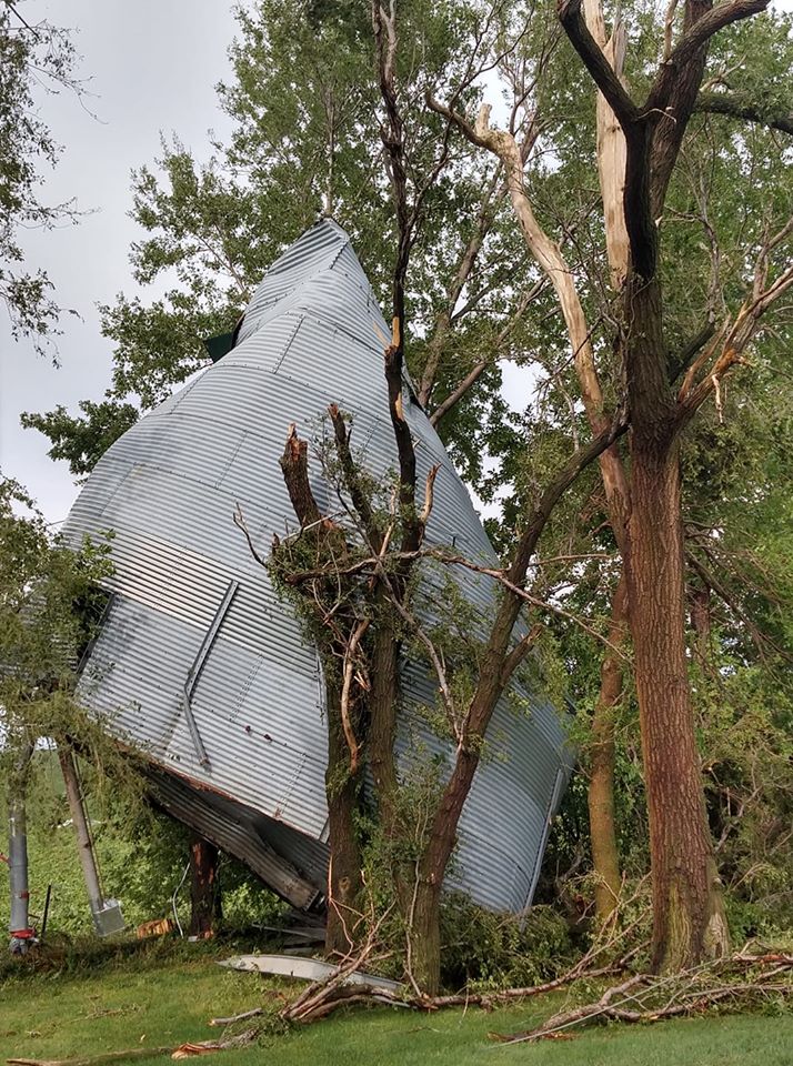
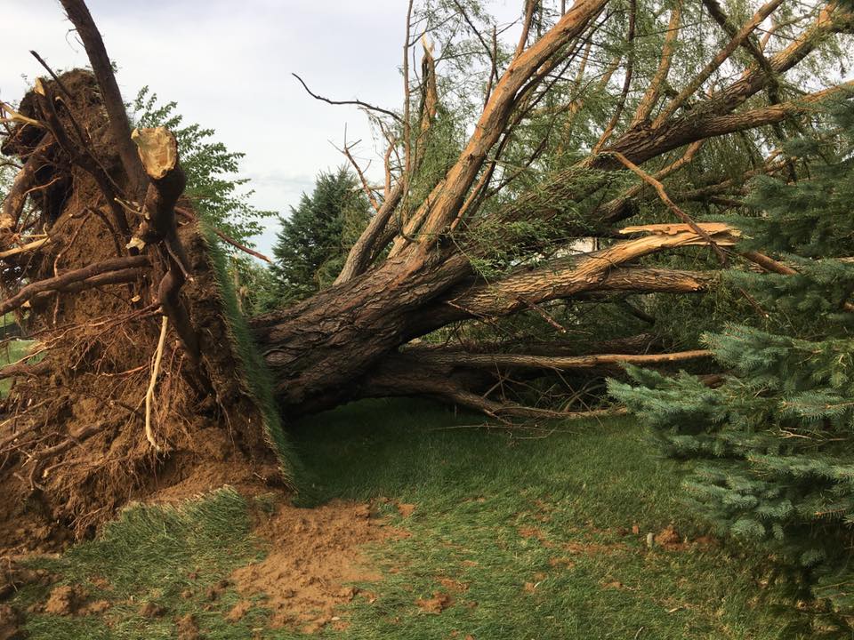
Ely, IA
 |
 |
 |
 |
| (Bob Lee) | (Bob Lee) | (Bob Lee) | (Bob Lee) |
Fulton, IL
 |
 |
 |
|
| (Larry, Twitter user @wotw824) | (Larry, Twitter user @wotw824) | (Larry, Twitter user @wotw82 |
Additional Photos
 |
 |
 |
 |
| Kewanee, IL (Tabitha Moore) |
Wheatland, IA (Lindsey Tiemessen) |
Wheatland, IA (Lindsey Tiemessen) |
Clinton, IA (Timothy Dohse) |
 |
 |
 |
 |
| Donahue, IA (Whitney Kyllo) |
Near Vinton, IA (Darrell Werning) |
Near Vinton, IA (Darrell Werning) |
Near Vinton, IA (Darrell Werning) |
 |
 |
 |
 |
| Shellsburg, IA (Glenn Rushworth) |
Washington, IA (Caleb Brunty) |
Washington, IA (Caleb Brunty) |
Washington, IA (Caleb Brunty) |
Radar
 |
|||
| Hourly radar images of the derecho's progression across the region. Image courtesy NWS Chicago (original). | |||
 |
|||
| Multi-Radar Multi-Sensor (MRMS) Radar |
Synced Radar and Video Imagery. Radar courtesy: Justin Gibbs, WDTD, Video: courtesy Evan Hindman
Tornadoes:
|
Tornado #1- just north of Eastern Iowa Airport
Track Map  
|
||||||||||||||||
|
Tornado #2- just south of Freeport, IL
Track Map 
|
||||||||||||||||
The Enhanced Fujita (EF) Scale classifies tornadoes into the following categories:
| EF0 Weak 65-85 mph |
EF1 Moderate 86-110 mph |
EF2 Significant 111-135 mph |
EF3 Severe 136-165 mph |
EF4 Extreme 166-200 mph |
EF5 Catastrophic 200+ mph |
 |
|||||
Storm Reports
| Interactive Storm Report Map | SPC Storm Reports |
 |
 |
PRELIMINARY LOCAL STORM REPORT...SUMMARY NATIONAL WEATHER SERVICE QUAD CITIES IA IL 929 PM CDT MON AUG 10 2020 ..TIME... ...EVENT... ...CITY LOCATION... ...LAT.LON... ..DATE... ....MAG.... ..COUNTY LOCATION..ST.. ...SOURCE.... ..REMARKS.. 0215 PM TSTM WND DMG 1 SSE MORRISON 41.80N 89.96W 08/10/2020 WHITESIDE IL TRAINED SPOTTER TREE LIMBS DOWN ABOUT 4 TO 6 INCHES IN DIAMETER OR LARGER IN MORRISON. TIME OF THE EVENT WAS ESTIMATED USING RADAR. 0150 PM TSTM WND DMG MONMOUTH 40.91N 90.65W 08/10/2020 WARREN IL EMERGENCY MNGR SEVERAL TREES AND POWERLINES DOWN IN TOWN. TIME OF THE EVENT WAS ESTIMATED USING RADAR. 0140 PM TSTM WND DMG LITTLE YORK 41.01N 90.75W 08/10/2020 WARREN IL EMERGENCY MNGR REPORTED THAT A FEW TREES WERE DOWN IN LITTLE WORK AS WELL AS POWER LINES. TIME OF THE EVENT WAS ESTIMATED USING RADAR. 0746 PM HEAVY RAIN 2 SE SCIOTO MILLS 42.33N 89.64W 08/10/2020 M2.00 INCH STEPHENSON IL TRAINED SPOTTER 0220 PM TSTM WND DMG FREEPORT 42.30N 89.61W 08/10/2020 STEPHENSON IL EMERGENCY MNGR 1700 PEOPLE WITHOUT POWER IN THE COUNTY, MANY IN THE CITY OF THE FREEPORT. NUMEROUS STREETS ARE BLOCKED DUE TO DOWN TREES AND POWER LINES. THE TIME OF THE EVENT WAS ESTIMATED USING RADAR. 0155 PM TSTM WND GST 2 N WADDAMS GROVE 42.45N 89.88W 08/10/2020 M58 MPH STEPHENSON IL PUBLIC HOME WEATHER STATION REPORTED 58 MPH GUSTS AND PEA SIZED HAIL. 0135 PM HAIL 1 NE FREEPORT 42.30N 89.62W 08/10/2020 E2.00 INCH STEPHENSON IL PUBLIC REPORTED AT FREEPORT, IL. 0150 PM TSTM WND GST 3 NNW MOLINE 41.52N 90.51W 08/10/2020 M85 MPH ROCK ISLAND IL MESONET CORRECTS PREVIOUS TSTM WND GST REPORT FROM 3 NNW MOLINE TO AD ADDIITIONAL INFORMATION. DOT RWIS ON I-74 BRIDGE THERE ARE NUMEROUS REPORTS OF OF POWERLINES AND TREES DOWN IN ROCK ISLAND AND MOLINE. 0148 PM TSTM WND GST MOLINE QUAD-CITY AIRPOR 41.45N 90.51W 08/10/2020 M79 MPH ROCK ISLAND IL ASOS 0145 PM TSTM WND DMG 1 SSW PORT BYRON 41.61N 90.33W 08/10/2020 ROCK ISLAND IL PUBLIC NUMEROUS PHOTOS OF TREES DOWN IN PORT BYRON VIA SOCIAL MEDIA. TIME OF THE EVENT WAS ESTIMATED USING RADAR. 0144 PM TSTM WND DMG 1 SSW MOLINE 41.47N 90.50W 08/10/2020 ROCK ISLAND IL EMERGENCY MNGR TREE LIMBS DOWN NEAR SOUTH PARK MALL. 0135 PM TSTM WND GST MOLINE QUAD-CITY AIRPOR 41.45N 90.51W 08/10/2020 M77 MPH ROCK ISLAND IL ASOS 0135 PM TSTM WND DMG 1 SW SILVIS 41.50N 90.42W 08/10/2020 ROCK ISLAND IL PUBLIC ESTIMATED TIME BY RADAR. LARGE TREE LIMBS DOWN AND ON TOP OF HOUSES. 0130 PM TSTM WND DMG 2 SSW COAL VALLEY 41.43N 90.46W 08/10/2020 ROCK ISLAND IL PUBLIC LOCATION ESTIMATED. TREE SNAPPED (1 FOOT DIAMETER ESTIMATED BY PHOTO). 0128 PM TSTM WND GST MOLINE QUAD-CITY AIRPOR 41.45N 90.50W 08/10/2020 M68 MPH ROCK ISLAND IL ASOS 0128 PM TSTM WND GST 3 WNW OAK GROVE 41.43N 90.62W 08/10/2020 E60 MPH ROCK ISLAND IL TRAINED SPOTTER 0200 PM TSTM WND DMG CABLE 41.28N 90.50W 08/10/2020 MERCER IL PUBLIC 4 TO 6 INCH TREE LIMB DOWN. PICTURE VIA SOCIAL MEDIA. 0133 PM TSTM WND DMG PREEMPTION 41.32N 90.58W 08/10/2020 MERCER IL PUBLIC VIA SOCIAL MEDIA. OLD BARN AND OTHER OUT BUILDINGS WITH ROOFS RIPPED OFF. TIME OF THE EVENT WAS ESTIMATED USING RADAR. 0840 PM HEAVY RAIN 3 N STOCKTON 42.40N 90.00W 08/10/2020 M1.37 INCH JO DAVIESS IL CO-OP OBSERVER STORM TOTAL. 0146 PM TSTM WND DMG NORA 42.46N 89.94W 08/10/2020 JO DAVIESS IL TRAINED SPOTTER CORRECTS PREVIOUS TSTM WND DMG REPORT FROM NORA TO CORRECT THE TIME. 6 INCH DIAMETER TREE LIMB DOWN. ESTIMATED WINDS OF 60 TO 70 MPH. TIME OF THE EVENT WAS ESTIMATED USING RADAR. 0215 PM TSTM WND DMG KEWANEE 41.24N 89.93W 08/10/2020 HENRY IL PUBLIC SEVERAL TREE LIMBS SNAPPED BASED ON PHOTO ABOUT 4 TO 6 INCHES IN DIAMETER. TRAMPOLINE WAS BLOWN OVER ON ITS SIDE. TIME OF THE EVENT WAS ESTIMATED BASED ON RADAR AND DURATION OF WINDS. 0153 PM TSTM WND DMG GENESEO 41.45N 90.15W 08/10/2020 HENRY IL PUBLIC VIA SOCIAL MEDIA,TWO LARGE TREE LIMBS DOWN IN THEIR YARD. TIME ESTIMATED USING RADAR AND DURATION. 0230 PM TSTM WND DMG 1 W LOMBARDVILLE 41.24N 89.66W 08/10/2020 BUREAU IL TRAINED SPOTTER 3-4 INCH TREE BRANCHES DOWN, TIME ESTIMATED FROM RADAR. 1238 PM TSTM WND DMG BRIGHTON 41.18N 91.82W 08/10/2020 WASHINGTON IA AMATEUR RADIO 4 INCH LIMB FROM A TREE SNAPPED AND OVER ROADWAY. 0202 PM TSTM WND GST PARK VIEW 41.69N 90.54W 08/10/2020 E70 MPH SCOTT IA NWS EMPLOYEE 60 TO 70 MPH WINDS ESTIMATED. TIME IS ALSO ESTIMATED. 0158 PM TSTM WND DMG 1 W RIVERDALE 41.53N 90.49W 08/10/2020 SCOTT IA TRAINED SPOTTER 8 INCH BRANCH SNAPPED AND NUMEROUS ADDITIONAL TREE DAMAGE. ALSO DAMAGE TO WOOD FENCE. 0152 PM TSTM WND GST 1 NNW BETTENDORF 41.58N 90.48W 08/10/2020 M68 MPH SCOTT IA PUBLIC 0147 PM TSTM WND DMG 1 WSW MOUNT JOY 41.61N 90.56W 08/10/2020 SCOTT IA NWS EMPLOYEE 4-5 SEMI TRAILERS BLOWN OVER ON HWY 61 BLOCKING TRAFFIC, TIME ESTIMATED FROM RADAR. 0145 PM TSTM WND GST DAVENPORT AIRPORT 41.61N 90.59W 08/10/2020 M86 MPH SCOTT IA ASOS CORRECTS PREVIOUS TSTM WND GST REPORT FROM DAVENPORT AIRPORT TO AD ADDITIONAL INFORMATION. NUMEROUS TREE LIMBS DOWN AROUND THE AIRPORT INCLUDING A 3 FOOT WIDE SYCAMORE TREE THAT WAS PARTIALLY ROTTED. SEVERAL LARGE TREE LIMBS DOWN. ONE POWER POLE WAS SNAPPED NEAR THE ENTRANCE TO THE AIRPORT. 0130 PM TSTM WND DMG BETTENDORF 41.56N 90.48W 08/10/2020 SCOTT IA PUBLIC ESTIMATED LOCATION AND TIME FROM RADAR. LARGE TREES DOWN. 0128 PM TSTM WND DMG 1 NW ELDRIDGE 41.65N 90.59W 08/10/2020 SCOTT IA TRAINED SPOTTER MULTIPLE TREES DOWN WITH VERY STRONG WINDS. 0128 PM TSTM WND DMG 2 WSW BETTENDORF 41.56N 90.50W 08/10/2020 SCOTT IA PUBLIC LARGE TREE UPROOTED AND LAYING ACROSS SOMEONES YARD. LARGE LIMBS THROUGHOUT THE STREET. 0126 PM TSTM WND GST DAVENPORT MUNICIPALITY 41.61N 90.58W 08/10/2020 M75 MPH SCOTT IA MESONET NWS OFFICE, RSOIS. 0125 PM TSTM WND GST DAVENPORT MUNICIPALITY 41.61N 90.58W 08/10/2020 M69 MPH SCOTT IA ASOS 60 KNOT GUST REPORTED AT DAVENPORT MUNICIPAL AIRPORT ASOS. 0123 PM TSTM WND DMG 2 SW DAVENPORT 41.54N 90.64W 08/10/2020 SCOTT IA PUBLIC FLAGPOLE BENT OVER. 0115 PM TSTM WND DMG DIXON 41.74N 90.78W 08/10/2020 SCOTT IA PUBLIC A LOT OF TREE DAMAGE THROUGHOUT THE TOWN. LARGE TREE LIMBS AND TREES DOWN. 0130 PM TSTM WND DMG 2 NNE NEW ERA 41.49N 90.89W 08/10/2020 MUSCATINE IA PUBLIC VIA SOCIAL MEDIA...TREES DOWN AND SOFFITT PEELED BACK ON AN OUTBUILDING NORTH OF WILDCAT DEN STATE PARK. TIME WAS ESTIMATED USING RADAR. 0115 PM TSTM WND GST MUSCATINE AIRPORT 41.37N 91.15W 08/10/2020 M58 MPH MUSCATINE IA ASOS 0105 PM TSTM WND DMG WEST LIBERTY 41.57N 91.26W 08/10/2020 MUSCATINE IA TRAINED SPOTTER SEVERAL LARGE TREE BRANCHES DOWN ALONG WITH SEVERAL POWER FLASHES. 0105 PM TSTM WND DMG 2 ENE MUSCATINE 41.43N 91.03W 08/10/2020 MUSCATINE IA PUBLIC ESTIMATED LOCATION. DOWNED TREES AND AN AMATEUR RADIO OPERATOR TOWER WENT DOWN. 0105 PM TSTM WND GST MUSCATINE 41.42N 91.07W 08/10/2020 E75 MPH MUSCATINE IA TRAINED SPOTTER ESTIMATING WIND GUSTS TO 75MPH. 0100 PM TSTM WND DMG 1 NNE MUSCATINE 41.44N 91.06W 08/10/2020 MUSCATINE IA PUBLIC ESTIMATED LOCATION. LARGE TREE DOWN. 0232 PM TSTM WND DMG 3 S CEDAR RAPIDS 41.93N 91.68W 08/10/2020 LINN IA PUBLIC EXTENSIVE DAMAGE TO BUILDINGS AT THIS INTERCHANGE. 0107 PM TSTM WND DMG 2 WNW MARION 42.04N 91.63W 08/10/2020 LINN IA TRAINED SPOTTER NO POWER AND LOTS OF 6-12 INCH DIAMETER TREES SNAPPED. ESTIMATING 90MPH WINDS. 0106 PM TSTM WND DMG SPRINGVILLE 42.06N 91.44W 08/10/2020 LINN IA PUBLIC SHINGLES COMPLETELY BLOWN OFF ROOF. 0101 PM TSTM WND DMG 2 E MARION 42.04N 91.55W 08/10/2020 LINN IA TRAINED SPOTTER DAMAGE TO MOBILE HOMES IN THE AREA OF INTERSECTION OF HIGHWAYS 13 AND 151. ESTIMATES OF WIND AROUND 90 MPH. 1258 PM TSTM WND DMG 4 ENE SHELLSBURG 42.12N 91.81W 08/10/2020 LINN IA EMERGENCY MNGR ESTIMATED GUSTS OVER 100 MPH WITH MULTIPLE CAMPERS BLOWN OVER, ALONG WITH THE SHELTER ROOF AT THE PARK BLOWN OFF. 1257 PM TSTM WND DMG 1 S HIAWATHA 42.03N 91.69W 08/10/2020 LINN IA TRAINED SPOTTER 2 FT DIAMETER TREES UPROOTED. SHINGLES TORN OFF HOUSE AND POWER OUT. 1256 PM TSTM WND DMG 2 NE MARION 42.05N 91.56W 08/10/2020 LINN IA TRAINED SPOTTER LARGE BRANCHES DOWN, PLAYGROUND EQUIPMENT BLOWN OUT OF YARDS. 1255 PM TSTM WND DMG 2 WSW HIAWATHA 42.04N 91.71W 08/10/2020 LINN IA TRAINED SPOTTER SEVERAL TREES DOWN IN HER NEIGHBORHOOD, TWO OF WHICH WERE IN HER YARD. 1255 PM TSTM WND GST 1 S MIDWAY 42.09N 91.70W 08/10/2020 M112 MPH LINN IA EMERGENCY MNGR 1249 PM TSTM WND GST HIAWATHA 42.05N 91.68W 08/10/2020 E100 MPH LINN IA EMERGENCY MNGR 1243 PM TSTM WND DMG 1 WNW CEDAR RAPIDS 41.98N 91.68W 08/10/2020 LINN IA TRAINED SPOTTER WIDESPREAD TREE DAMAGE IN CEDAR RAPIDS, WITH VERY HIGH WINDS. NUMEROUS POWER OUTAGES. 1242 PM TSTM WND DMG 2 W CEDAR RAPIDS 41.98N 91.71W 08/10/2020 LINN IA TRAINED SPOTTER MULTIPLE TREES AND BRANCHES DOWN. 1240 PM TSTM WND DMG 2 S TODDVILLE 42.07N 91.72W 08/10/2020 LINN IA TRAINED SPOTTER A LOT OF TREE DAMAGE WITH LARGE OAK TREES SNAPPED HALF WAY UP. AN OUTBUILDING WAS TOSSED INTO A FIELD AND A LARGE AMOUNT OF CORN DAMAGE WAS OBSERVED IN THE AREA. 1238 PM TSTM WND DMG HIAWATHA 42.05N 91.68W 08/10/2020 LINN IA TRAINED SPOTTER ESTIMATED WIND GUSTS UP TO 80 MPH. 1235 PM TSTM WND DMG FAIRFAX 41.92N 91.78W 08/10/2020 LINN IA TRAINED SPOTTER WINDS IN EXCESS OF 80 MPH WITH LARGE LIMBS DOWN. 1235 PM TSTM WND DMG 4 NNW ELY 41.92N 91.61W 08/10/2020 LINN IA TRAINED SPOTTER TREES SNAPPED IN HALF, AROUND 12 INCH DIAMETER (ESTIMATED BY PHOTOS). 1235 PM TSTM WND DMG 3 NE CEDAR RAPIDS 42.00N 91.64W 08/10/2020 LINN IA TRAINED SPOTTER LARGE MATURE TREES DOWN AT LINN/BENTON RD. 1234 PM TSTM WND GST 1 ENE FAIRFAX 41.93N 91.76W 08/10/2020 M74 MPH LINN IA TRAINED SPOTTER MEASURED WITH HANDHELD ANEMOMETER. 1232 PM TSTM WND GST 3 W CEDAR RAPIDS 41.97N 91.74W 08/10/2020 M73 MPH LINN IA TRAINED SPOTTER LOTS OF TREE DAMAGE WITH A LARGE BIRCH TREE FALLEN. 1230 PM TSTM WND GST CEDAR RAPIDS MUNICIPALI 41.89N 91.71W 08/10/2020 M68 MPH LINN IA ASOS 1230 PM TSTM WND DMG 2 WSW CEDAR RAPIDS 41.96N 91.71W 08/10/2020 LINN IA PUBLIC HEAVY DAMAGE REPORTED AT THE HOUSBY HEAVY EQUIPMENT BUILDING. 1230 PM TSTM WND DMG ALBURNETT 42.15N 91.62W 08/10/2020 LINN IA PUBLIC ESTIMATED TIME. MAJOR TREE DAMAGE AND SHINGLES EVERYWHERE. 1230 PM TSTM WND DMG 3 WSW CEDAR RAPIDS 41.96N 91.73W 08/10/2020 LINN IA PUBLIC LARGE TREES DOWN. 1230 PM TSTM WND DMG 3 ESE HIAWATHA 42.03N 91.64W 08/10/2020 LINN IA PUBLIC LOCATION IS AT WGAN. SEVERAL TREES DOWN AND SNAPPED AROUND PROPERTY, ALONG WITH HEAVY DAMAGE TO SATELLITES AT THEIR BUILDING. 1230 PM TSTM WND DMG 2 SW HIAWATHA 42.03N 91.70W 08/10/2020 LINN IA PUBLIC ESTIMATED LOCATION. SEVERAL TREES SNAPPED CLEAN AT THE MIDDLE IN WOODED AREA. 1220 PM TSTM WND DMG FAIRFAX 41.92N 91.78W 08/10/2020 LINN IA PUBLIC A BUNCH OF DAMAGE DONE TO TREES, ROOFING MISSING ON SEVERAL BUILDINGS, AND A BUILDING WAS DESTROYED. 0130 PM TSTM WND DMG 2 NNE STONE CITY 42.14N 91.33W 08/10/2020 JONES IA TRAINED SPOTTER LOST AN OLD HICKORY TREE AND ANOTHER 18 INCH DIAMETER TREE WAS BROKEN OFF HALFWAY UP. STRONG WINDS LASTED UNTIL 2 PM. TIME OF THE EVENT WAS ESTIMATED USING RADAR. 0100 PM TSTM WND DMG OLIN 42.00N 91.14W 08/10/2020 JONES IA PUBLIC LARGE TREE LIMBS AND FENCES ARE DOWN. 0100 PM TSTM WND DMG 1 E ANAMOSA 42.11N 91.26W 08/10/2020 JONES IA EMERGENCY MNGR THE EMERGENCY MANAGER RELAYED NUMEROUS REPORTS OF WIDESPREAD TREES, POWERLINES AND LIMBS DOWN THROUGHOUT THE COUNTY. THE TIME OF THE EVENT WAS ESTIMATED USING RADAR. 0105 PM TSTM WND DMG 2 SE IOWA CITY 41.64N 91.51W 08/10/2020 JOHNSON IA TRAINED SPOTTER SEVERAL TREE BRANCHES BLOWN TO THE GROUND, UP TO 3 INCHES IN DIAMETER. NO POWER. PERSONAL WEATHER STATION RECORDED 69 KNOTS BEFORE THE POWER WENT OUT. 1252 PM TSTM WND GST TIFFIN 41.71N 91.68W 08/10/2020 M73 MPH JOHNSON IA TRAINED SPOTTER GUST MEASURED WITH DAVIS WEATHER STATION. 1245 PM TSTM WND GST 4 ENE IOWA CITY 41.67N 91.47W 08/10/2020 E70 MPH JOHNSON IA TRAINED SPOTTER MINOR DAMAGE TO NEW CONSTRUCTION SITES. 1240 PM TSTM WND DMG 1 ESE IOWA CITY 41.65N 91.52W 08/10/2020 JOHNSON IA TRAINED SPOTTER MULTIPLE TRANSFORMERS HAVE BLOWN, WITH LARGE TREE LIMBS DOWN IN TOWN. 1239 PM TSTM WND GST IOWA CITY AIRPORT 41.64N 91.54W 08/10/2020 M69 MPH JOHNSON IA ASOS CORRECTS PREVIOUS TSTM WND GST REPORT FROM IOWA CITY AIRPORT. 1237 PM TSTM WND DMG 1 NNE OAKDALE 41.71N 91.59W 08/10/2020 JOHNSON IA TRAINED SPOTTER 3 TREES TOPS KNOCKED OUT. MULTIPLE LIMBS DOWN IN THE AREA. 1235 PM TSTM WND DMG 3 SW CORALVILLE 41.66N 91.63W 08/10/2020 JOHNSON IA PUBLIC LARGE TREE SNAPPED. 80 FT LONG TREE THAT WAS ABOUT A FOOT IN DIAMETER. 1258 PM TSTM WND DMG 2 ESE FAIRFIELD 41.00N 91.94W 08/10/2020 JEFFERSON IA TRAINED SPOTTER SMALL TO MEDIUM TREE LIMBS DOWN WITHIN TOWN. 1250 PM TSTM WND GST 1 S FAIRFIELD 40.99N 91.96W 08/10/2020 E70 MPH JEFFERSON IA TRAINED SPOTTER 60-70 MPH WINDS ESTIMATED. 1235 PM TSTM WND GST FAIRFIELD MUNICIPALITY 41.05N 91.98W 08/10/2020 M60 MPH JEFFERSON IA PUBLIC 1240 PM TSTM WND DMG 2 SSW WILLIAMSBURG 41.64N 92.02W 08/10/2020 IOWA IA TRAINED SPOTTER NUMEROUS LARGE 1 FT DIAMETER OR LARGER TREES SNAPPED. 1240 PM TSTM WND GST AMANA 41.80N 91.88W 08/10/2020 E70 MPH IOWA IA TRAINED SPOTTER TIME ESTIMATED FROM RADAR. 1240 PM TSTM WND DMG AMANA 41.80N 91.87W 08/10/2020 IOWA IA TRAINED SPOTTER SEVERAL LARGE 12 INCH TREE LIMBS DOWN, TIME ESTIMATED FROM RADAR. 1255 PM TSTM WND GST MOUNT PLEASANT AIRPORT 40.95N 91.51W 08/10/2020 M58 MPH HENRY IA AWOS 0125 PM HAIL 1 ENE CASCADE 42.30N 90.99W 08/10/2020 E1.00 INCH DUBUQUE IA TRAINED SPOTTER 0100 PM TSTM WND DMG ASBURY 42.51N 90.75W 08/10/2020 DUBUQUE IA AMATEUR RADIO 70 FT TALL TREE TOPPLED. 0130 PM TSTM WND DMG 1 E WEST BURLINGTON 40.82N 91.16W 08/10/2020 DES MOINES IA TRAINED SPOTTER TREES DOWN ACROSS ROAD, TIME ESTIMATED FROM RADAR. 0127 PM TSTM WND DMG MEDIAPOLIS 41.01N 91.16W 08/10/2020 DES MOINES IA TRAINED SPOTTER NUMEROUS TREE BRANCHES DOWN ALL OVER TOWN, TIME ESTIMATED FROM RADAR. 0124 PM TSTM WND DMG DANVILLE 40.86N 91.31W 08/10/2020 DES MOINES IA EMERGENCY MNGR 6 INCH TREE LIMBS DOWN ACROSS POWER LINES. 0122 PM TSTM WND GST BURLINGTON REGIONAL AIR 40.78N 91.12W 08/10/2020 M60 MPH DES MOINES IA ASOS 0200 PM TSTM WND GST CLINTON AIRPORT 41.83N 90.33W 08/10/2020 M74 MPH CLINTON IA AWOS 0200 PM TSTM WND DMG 1 NNE CLINTON 41.85N 90.23W 08/10/2020 CLINTON IA EMERGENCY MNGR NUMEROUS REPORTS OF TREES, LIMBS ANDPOWERLINES DOWN IN THE COUNTY. CLINTON AWOS SHOWS GUSTS OVER 60 MPH FOR ABOUT 45 MINUTES. TIME OF THE EVENT WAS ESTIMATED BASED ON RADAR AND DURATION. 0147 PM TSTM WND DMG 5 N CLINTON 41.91N 90.23W 08/10/2020 CLINTON IA TRAINED SPOTTER SIGNIFICANT ROOF DAMAGE AT RADIO STATION KMCN, WITH ROOFING AND INSULATION MATERIAL BLOWN INTO ADJACENT FIELD. 0145 PM TSTM WND GST CLINTON AIRPORT 41.83N 90.33W 08/10/2020 M69 MPH CLINTON IA AWOS 0112 PM TSTM WND GST BENNETT 41.74N 90.97W 08/10/2020 E70 MPH CEDAR IA TRAINED SPOTTER TREE LIMBS EVERYWHERE. 0105 PM TSTM WND DMG LOWDEN 41.86N 90.92W 08/10/2020 CEDAR IA CO-OP OBSERVER LARGE TREE BRANCHES BLOWN OFF TREES WITH AN ESTIMATE AT 60+MPH WINDS. 0100 PM TSTM WND GST 2 W LIME CITY 41.65N 91.13W 08/10/2020 M61 MPH CEDAR IA MESONET IA-DOT. 1251 PM TSTM WND GST WEST BRANCH 41.67N 91.35W 08/10/2020 M70 MPH CEDAR IA EMERGENCY MNGR 1244 PM TSTM WND GST VINTON 42.17N 92.03W 08/10/2020 M70 MPH BENTON IA EMERGENCY MNGR REPORTED A MEASURED GUST OF 70 MPH. 1231 PM TSTM WND GST ATKINS 42.00N 91.86W 08/10/2020 E90 MPH BENTON IA LAW ENFORCEMENT FIRE DEPARTMENT REPORTED WINDS AROUND 90 MPH. 1228 PM TSTM WND GST 6 NNE VAN HORNE 42.08N 92.03W 08/10/2020 E70 MPH BENTON IA TRAINED SPOTTER 1225 PM TSTM WND GST BLAIRSTOWN 41.91N 92.08W 08/10/2020 E90 MPH BENTON IA EMERGENCY MNGR WINDS IN EXCESS OF 90 MPH WITH MAJOR DAMAGE REPORTED IN TOWN. 1215 PM TSTM WND GST BELLE PLAINE 41.90N 92.27W 08/10/2020 M70 MPH BENTON IA EMERGENCY MNGR MULTIPLE SPOTTER REPORTS OF 70+ MPH WINDS FROM BELLE PLAINE TO LUZERNE.
Wind Reports
...HIGHEST WIND REPORTS AUG 10 (OBSERVING SITES)...
Observations are collected from a variety of sources with varying equipment and exposures.
We thank all volunteer weather observers for their dedication. Not all data listed are
considered official.
Location                     Speed     Time/Date       Provider
2 NW Moline                  85 MPH    0150 PM 08/10   IADOT
Quad City Intl Arpt          79 MPH    0148 PM 08/10   ASOS
Clinton Arpt                 74 MPH    0200 PM 08/10   AWOS
0.7 W Belle Plaine (UPR)     70 MPH    1215 PM 08/10   MESOWEST
Mechanicsville (UPR)         69 MPH    0110 PM 08/10   MESOWEST
Cedar Rapids Arpt            68 MPH    1230 PM 08/10   ASOS
0.6 W Lowden (UPR)           63 MPH    0140 PM 08/10   MESOWEST
2 W University Heights       62 MPH    0110 PM 08/10   IADOT
2 W Lime City                62 MPH    0100 PM 08/10   IADOT
Burlington Arpt              60 MPH    0122 PM 08/10   ASOS
Fairfield Arpt               60 MPH    1235 PM 08/10   AWOS
1 N Williamsburg             60 MPH    1220 PM 08/10   IADOT
Mount Pleasant Arpt          58 MPH    1255 PM 08/10   AWOS
Muscatine Arpt               58 MPH    0115 PM 08/10   AWOS
Savanna Arpt                 56 MPH    0155 PM 08/10   AWOS
Sterling/Rock Falls Arpt     56 MPH    0226 PM 08/10   AWOS
Maquoketa                    55 MPH    0140 PM 08/10   IADOT
PRELIMINARY LOCAL STORM REPORT...SUMMARY
NATIONAL WEATHER SERVICE QUAD CITIES IA IL

...SELECT WIND GUST REPORTS OVER 70 MPH...


..TIME...   ...EVENT...      ...CITY LOCATION...     ...LAT.LON...
..DATE...   ....MAG....      ..COUNTY LOCATION..ST.. ...SOURCE....
0145 PM     TSTM WND GST     DAVENPORT AIRPORT       41.61N 90.59W
08/10/2020  M86 MPH          SCOTT              IA   ASOS


0126 PM     TSTM WND GST     DAVENPORT MUNICIPALITY  41.61N 90.58W
08/10/2020  M75 MPH          SCOTT              IA   MESONET

            NWS OFFICE, RSOIS.


1255 PM     TSTM WND GST     1 S MIDWAY              42.09N 91.70W
08/10/2020  M112 MPH         LINN               IA   EMERGENCY MNGR


1250 PM     TSTM WND GST     1 S FAIRFIELD           40.99N 91.96W
08/10/2020  E70 MPH          JEFFERSON          IA   TRAINED SPOTTER

            60-70 MPH WINDS ESTIMATED.


1249 PM     TSTM WND GST     HIAWATHA                42.05N 91.68W
08/10/2020  E100 MPH         LINN               IA   EMERGENCY MNGR


1234 PM     TSTM WND GST     1 ENE FAIRFAX           41.93N 91.76W
08/10/2020  M74 MPH          LINN               IA   TRAINED SPOTTER

            MEASURED WITH HANDHELD ANEMOMETER.


1232 PM     TSTM WND GST     3 W CEDAR RAPIDS        41.97N 91.74W
08/10/2020  M73 MPH          LINN               IA   TRAINED SPOTTER

            LOTS OF TREE DAMAGE WITH A LARGE BIRCH TREE
            FALLEN.


1252 PM     TSTM WND GST     TIFFIN                  41.71N 91.68W
08/10/2020  M73 MPH          JOHNSON            IA   TRAINED SPOTTER

            GUST MEASURED WITH DAVIS WEATHER STATION.


1245 PM     TSTM WND GST     4 ENE IOWA CITY         41.67N 91.47W
08/10/2020  E70 MPH          JOHNSON            IA   TRAINED SPOTTER

            MINOR DAMAGE TO NEW CONSTRUCTION SITES.
0200 PM     TSTM WND GST     CLINTON AIRPORT         41.83N 90.33W
08/10/2020  M74 MPH          CLINTON            IA   AWOS
0202 PM     TSTM WND GST     PARK VIEW               41.69N 90.54W
08/10/2020  E70 MPH          SCOTT              IA   NWS EMPLOYEE

            60 TO 70 MPH WINDS ESTIMATED. TIME IS ALSO
            ESTIMATED.
0112 PM     TSTM WND GST     BENNETT                 41.74N 90.97W
08/10/2020  E70 MPH          CEDAR              IA   TRAINED SPOTTER

            TREE LIMBS EVERYWHERE.


1251 PM     TSTM WND GST     WEST BRANCH             41.67N 91.35W
08/10/2020  M70 MPH          CEDAR              IA   EMERGENCY MNGR


1244 PM     TSTM WND GST     VINTON                  42.17N 92.03W
08/10/2020  M70 MPH          BENTON             IA   EMERGENCY MNGR

            REPORTED A MEASURED GUST OF 70 MPH.


1231 PM     TSTM WND GST     ATKINS                  42.00N 91.86W
08/10/2020  E90 MPH          BENTON             IA   LAW ENFORCEMENT

            FIRE DEPARTMENT REPORTED WINDS AROUND 90
            MPH.


1228 PM     TSTM WND GST     6 NNE VAN HORNE         42.08N 92.03W
08/10/2020  E70 MPH          BENTON             IA   TRAINED SPOTTER


1225 PM     TSTM WND GST     BLAIRSTOWN              41.91N 92.08W
08/10/2020  E90 MPH          BENTON             IA   EMERGENCY MNGR

            WINDS IN EXCESS OF 90 MPH WITH MAJOR DAMAGE
            REPORTED IN TOWN.


1215 PM     TSTM WND GST     BELLE PLAINE            41.90N 92.27W
08/10/2020  M70 MPH          BENTON             IA   EMERGENCY MNGR

            MULTIPLE SPOTTER REPORTS OF 70+ MPH WINDS
            FROM BELLE PLAINE TO LUZERNE.
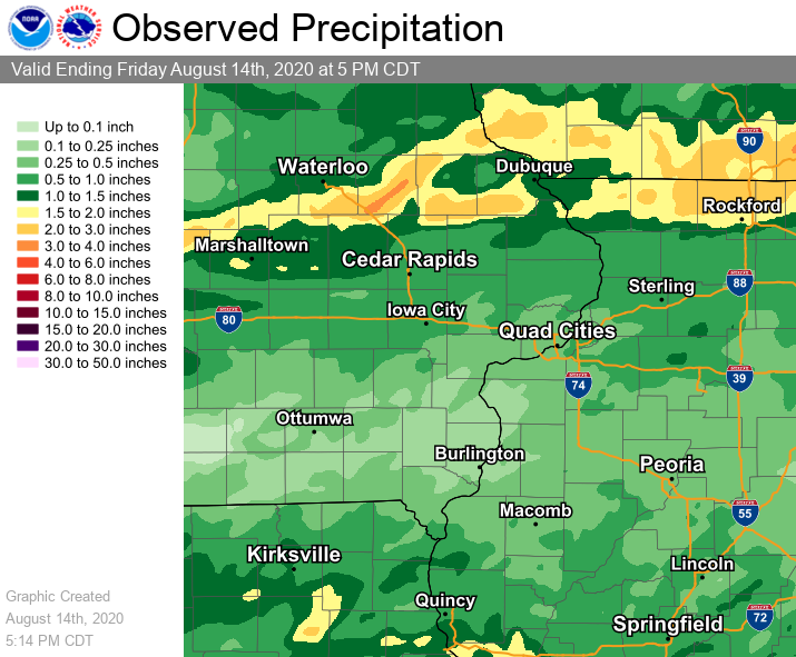
Rain Reports
|
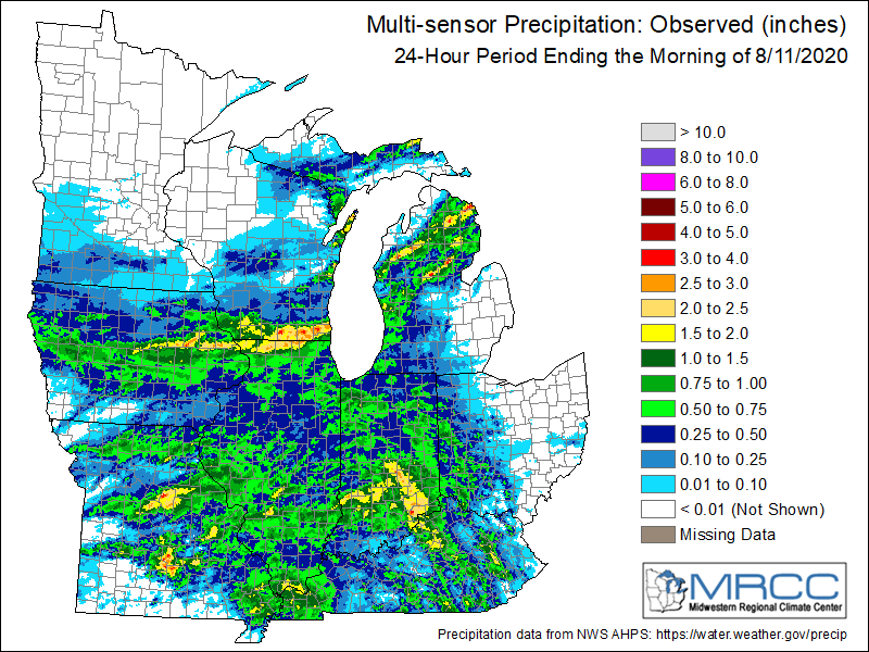
Local Rainfall Analysis
|
Regional Rainfall Analysis
Courtesy of Midwest Regional Climate Cente |
....IOWA.... Center Junction 2.6 W 2.03 Hopkinton 5.4 WSW 1.98 Fairfax 4.0 NW 1.59 Marshalltown 1 NW 1.42 Dubuque #3 7 SW 1.40 Monticello 1 E 1.37 Dubuque Arpt 1.30 Toledo 3 N 0.88 Perry 0 W 0.84 Charlotte 1.9 WNW 0.83 Boone 1 SSW 0.76 Central City 6.7 W 0.68 Manchester 0.68 Guttenberg Dam 10 0.58 Tipton 0.7 N 0.57 NWS Johnston* 5 NNW 0.55 Keokuk LD19 0.52 Le Claire LD14 0.51 Nichols 3.2 SSW 0.48 Eldridge 0.6 ESE 0.46 Iowa City 0.45 Asbury 0.4 SW 0.44 Rickardsville 0.2 W 0.43 Muscatine 2N 0.42 Marengo 2.6 SSW 0.42 Dubuque LD11 0.41 Park View 0.2 WSW 0.41 Fayette 1 NW 0.40 Burlington 6.5 SSW 0.38 Oelwein AWOS 0.38 Independence 1.2 N 0.37 Pella 4 N 0.35 Eldridge 0.7 SSW 0.27 Oskaloosa 1 NNW 0.26 Sigourney 0.25 Ainsworth 7.4 N 0.24 Donnellson 0.21 Rathbun Reservoir 2 N 0.20 Burlington Arpt 2 SW 0.20 Elkader 6SSW 0.19 Centerville 0 NE 0.18 Waterloo ASOS 5 NW 0.18 West Point 7.5 NW 0.15 Washington 5.8 SW 0.14 Washington 0.13 Mason City 1 NNE 0.13 Salem 1S 0.11 Salem 3.1 ESE 0.11 Oskaloosa AWOS 9 ESE 0.08 Wapello 5.4 SE 0.07 Morning Sun 1.7 E 0.07 Mason City ASOS 6 W 0.06 Tripoli 0 N 0.06 Waukon 3N 0.05 Columbus Jct 2 SSW 0.04 Hampton 1 N 0.03 Beaconsfield 1 NNE 0.00 Pella AWOS 2 WSW 0.00 ....ILLINOIS.... Orangeville 2.8 NW 3.12 Freeport 1.7 ESE 2.91 Freeport 1.2 E 2.60 Freeport 2.52 Roscoe 2SE 2.48 Freeport 1.7 NW 2.19 Freeport 2.0 NW 1.94 Winslow 4.3 ESE 1.73 Elizabeth 1.49 Lanark 5.3 N 1.47 Ridott 0.1 NE 1.20 Mount Carroll 0.84 Bentley 0.63 Atkinson 2.6 NNE 0.61 Aledo 0.58 Steward 0.56 Jacksonville AWOS 0.55 Macomb 3.8 NW 0.55 Jacksonville 2E 0.55 Galesburg 0.52 Rockford ASOS 0.51 Havana 0.50 Coal Valley 2.6 E 0.50 Geneseo 2.0 NW 0.50 Princeton 0.48 Paw Paw 1 E 0.47 Mundelein 0.46 New Windsor 2.0 N 0.46 Romeoville 0.45 Mendota 2 SE 0.41 Peoria ASOS 0.41 Altona 0.41 Lincoln NWS 0.40 Kewanee 1 E 0.39 Galesburg Arpt 3 SW 0.39 Galva 2.7 NE 0.38 Colchester 3.5 NE 0.38 Tuscola 0.38 Ogden 0.37 La Harpe 0.35 Alpha 0.7 N 0.34 Dallas City 3.0 SSE 0.34 Alexis 1 SW 0.33 Windsor 0.32 Ottawa 4 SW 0.30 Alpha 2.3 N 0.27 Decatur Airport 0.24 St Anne 0.24 New Boston LD17 0.17 Bloomington Airport 0.17 Oquawka 0.5 N 0.12 Gladstone LD18 0.07 Rochelle AWOS 0.00 ....MISSOURI.... Columbia 1.18 Kirksville ASOS 0.64 Chillicothe 2 NW 0.56 |
Environment
SPC EVENT REVIEW PAGE: 08/10/2020
SPC Categorical/Tornado/Hail/Wind Outlooks
 |
 |
 |
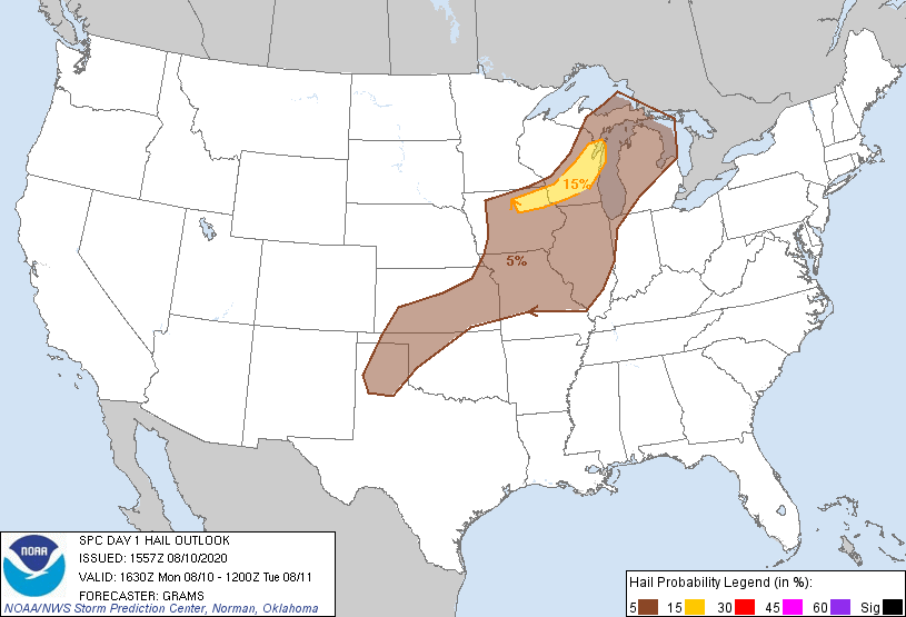 |
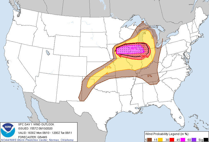
| SPC Categorical Outlook | Tornado Outlook | Wind Outlook | Hail Outlook |
Notable Analysis From The Area
 |
 |
 |
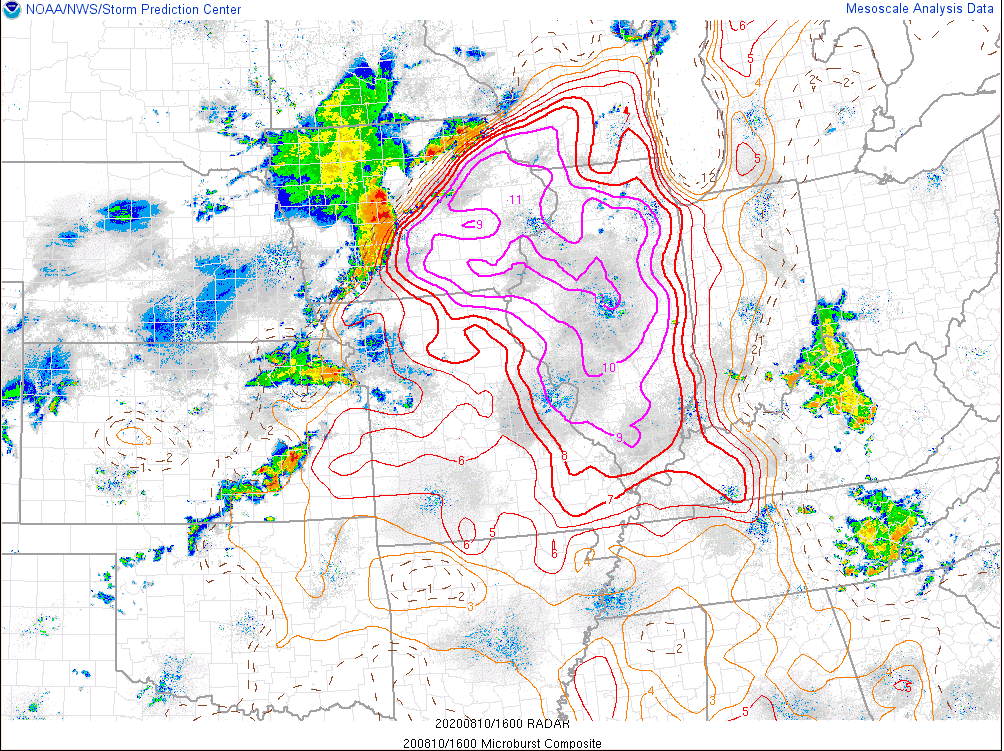 |
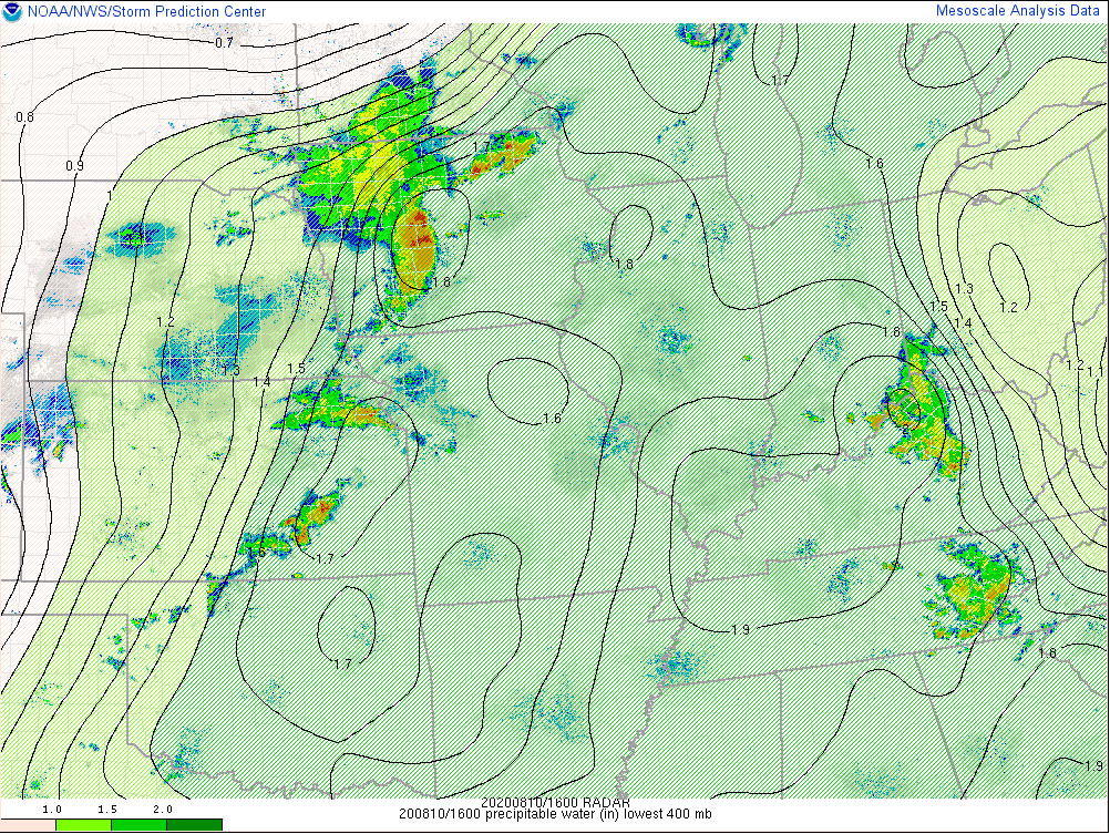
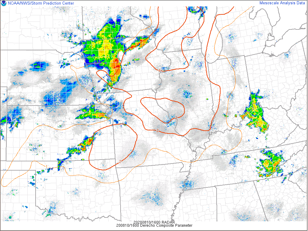
| Precipitable Water (SPC) | Surface Based CAPE (SPC) | Derecho Composite (SPC) | Microburst Composite (SPC) |
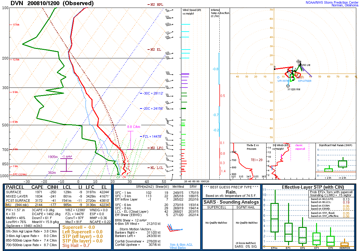
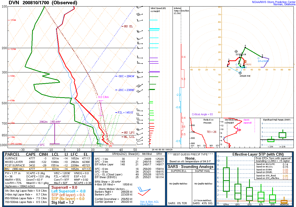
DVN Observed Sounding Analysis
 |
 |
| 7 AM DAVENPORT, IA SOUNDING | NOON DAVENPORT, IA SOUNDING |
SPC Mesoscale Discussions
 |
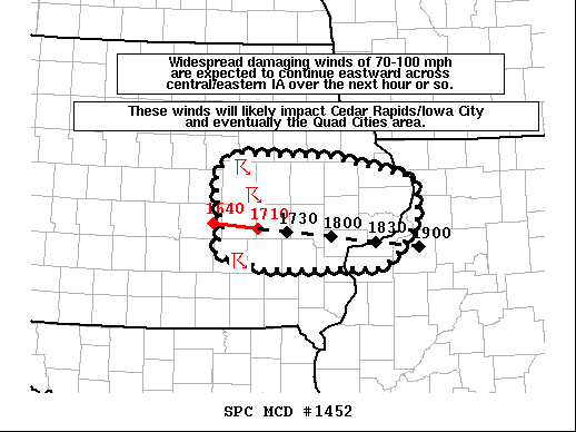 |
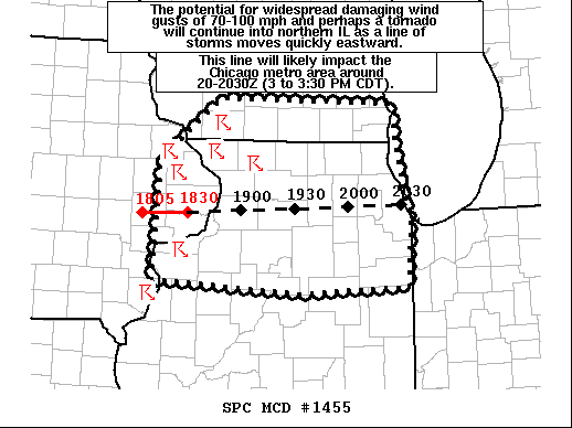 |
|
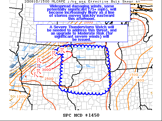
| Mesoscale Discussion #1450 | Mesoscale Discussion #1452 | Mesoscale Discussion #1455 |
SPC Convective Watches
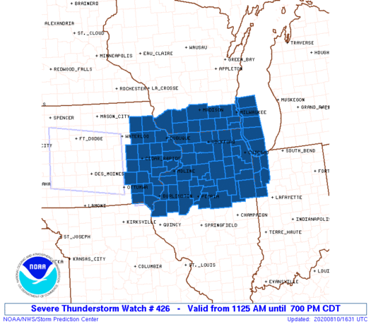 |
| PDS Severe Thunderstorm Watch #426 |
Additional Information
 |
 |
| NASA TERRA satellite MODIS imagery between July 28th, 2020 and August 11th, 2020 showing approximate damage to cropland from derecho. Image courtesy MODIS Today at Univ of Wisconsin - Madison Space Science and Engineering Center | NASA/NOAA Suomi Visible Infrared Imaging Radiometer Suite (VIIRS) Day/Night Band showing the nighttime lights in Iowa. The loop starts on the morning of August 10, 2020 before the derecho as a reference of nighttime lights in Iowa. The following images shows the progression from peak power outages on the morning of August 11 to the gradually and ongoing restoration on the mornings of the 12th, 14th, and 16th. Not all nights were cloudless so 'blurring' of lights may occur in some areas. Courtesy NASA Worldview. |
Summaries from other NWS Offices
 |
Media use of NWS Web News Stories is encouraged! Please acknowledge the NWS as the source of any news information accessed from this site. |
|


 Follow us on YouTube